GIS24.net
Geographic Information System
POI database from MEINWOMOmaps


Geographic Information System
POI database from MEINWOMOmaps
Mont-Blanc-Tunnel
/
ADDRESS
74400 Chamonix-Mont-BlancTunnel du Mont Blanc
WeiterUrl : https:/ / de.wikipedia.org/ wiki/ Mont-Blanc-Tunnel
UrlLoad : https:/ / yes
WikiText : Der Mont-Blanc-Tunnel (französisch: Tunnel du Mont-Blanc, italienisch: Tunnel del Monte Bianco) ist ein Straßentunnel durch das Montblanc-Massiv, der die Städte Chamonix-Mont-Blanc im Dpartement Haute-Savoie (Frankreich) mit Courmayeur (A5) im Aostatal (Italien) verbindet. Der Mont-Blanc-Tunnel besteht aus einer einzigen Röhre mit einer Doppelspur (Gegenverkehr). Das Projekt einer zweiten Röhre wurde zunächst wegen fehlender Finanzierung und dann wegen Widerstand der betroffenen Anwohner verworfen. Die Gesamtlänge des Tunnels beträgt 11,6 ,km. Die Eintrittshöhe auf französischer Seite liegt bei 1.274 ,m, auf italienischer Seite bei 1.381 ,m ,s.l.m.. Im Längsschnitt des Tunnels erkennt man den Verlauf eines umgedrehten V, um den Abfluss des Wassers zu beiden Seiten zu gewährleisten. Der höchste Punkt im Streckenverlauf liegt genau unterhalb des Berges Aiguille du Midi.
Click for interactive map
..
Pictures of the Poi and surroundings
.
Things to see in the area
Pointe Heilbronner
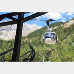 Not exactly cheap but fantastic cable car ride to the Pointe Heilbronner with a view of the nearby Mont Blanc, the Matterhorn and the Italian 4000s: Monte Rosa, Gran Paradiso hiking possibilities, restaurant
[ click for more information ]