GIS24.net
Geographic Information System
POI database from MEINWOMOmaps


Geographic Information System
POI database from MEINWOMOmaps
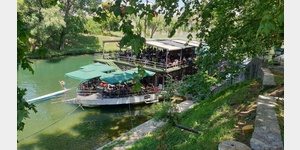
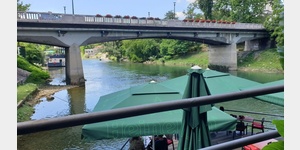
Vrbanja
/
ADDRESS
051 Banja Luka, Kumsale
Nasip
WeiterUrl : https:/ / de.wikipedia.org/ wiki/ Vrbanja
UrlLoad : https:/ / yes
WikiText : Vorlage:Infobox Fluss/BILD_fehltVorlage:Infobox Fluss/GKZ_fehltVorlage:Infobox Fluss/MNDUNGSHHE_fehltVorlage:Infobox Fluss/ABFLUSSWEG_fehltVorlage:Infobox Fluss/ABFLUSS_fehltVorlage:Infobox Fluss/KARTE_fehlt Die Vrbanja (kyrillisch ) ist ein rechter Nebenfluss des Vrbas. Sie entspringt am Nordhang des kargen, bis 1919 m hohen Vla¡i-Gebirges nördlich von Travnik und mündet in Banja Luka in den Vrbas. Die Quelle der Vrbanja liegt in 1520 m Höhe. Der Fluss verläuft - von den ersten Kilometern abgesehen - ausschließlich in der Republika Srpska und durch enge Täler inmitten von dicht bewaldeten Gebirgen. Lediglich bei Kotor Varo¡ öffnet sich das Tal etwas. In elinac mündet von rechts mit der Jo¡avka der größte Nebenfluss ein.
Click for interactive map
..
Pictures of the Poi and surroundings
.
Things to see in the area
ParkenAll
[ click for more information ]ParkenAll
[ click for more information ]Apotheke
[ click for more information ]Konzum
[ click for more information ]Orthodoxe Kirche der Heiligen Dreifaltigkeit
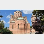 Built in neo-Byzantine style between 1993 and 2004, the orthodox cathedral stands on the site of an earlier pre-WWII church.
 [ click for more information ]
Parkenprivat
[ click for more information ]ParkenAll
[ click for more information ]Kathedrale von Christus dem Erlöser
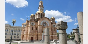 Built in neo-Byzantine style between 1993 and 2004, the orthodox cathedral stands on the site of an earlier pre-WWII church.
[ click for more information ]
Festung Kastel
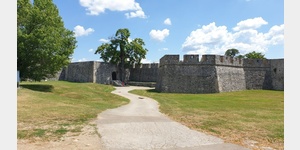 The fortress was built in the Middle Ages on the remains of Roman fortifications.
 [ click for more information ]
Ferhat-Pascha-Moschee
Built in 2016, the mosque is a faithful reconstruction of the historic 16th-century mosque that was demolished in the 20th century.[ click for more information ]