GIS24.net
Geographic Information System
POI database from MEINWOMOmaps


Geographic Information System
POI database from MEINWOMOmaps
Cap de Creus
/
ADDRESS
WeiterUrl : https:/ / de.wikipedia.org/ wiki/ Cap de Creus
UrlLoad : https:/ / yes
WikiText : Der Naturpark Cap de Creus reicht von der Serra de Roda bis zur östlichsten Spitze der iberischen Halbinsel. Hier fallen die Ausläufer der Pyrenäen ins Mittelmeer. Seinen Namen (Kap des Kreuzes) hat der rund 108 Quadratkilometer große Naturpark von der gleichnamigen Halbinsel, die wiederum nach der alten Wallfahrtskirche St. Helena oder Hl. Kreuz am Kloster Sant Pere de Rodes benannt ist. Das Cap de Creus bildet die nördliche Begrenzung des Golfes von Roses an der nördlichen Costa Brava. In Cap de Creus endet der Fernwanderweg GR 11, welcher quer durch die Pyrenäen bis zur Atlantikküste verläuft.
Click for interactive map
..
Pictures of the Poi and surroundings
Videos about the Poi and the surrounding area
.
.
Things to see in the area
Cap de Creus
[ click for more information ]Far de Cap de Creus
[ click for more information ]Punta d´en Codera
[ click for more information ]Badia de Guillola
[ click for more information ]Cap d´en Roig
[ click for more information ]Punta de s´Alqueria
[ click for more information ]Punta de s´Oliguera
[ click for more information ]Radtour zum Leuchtturm
[ click for more information ]House Museum Salvador Dalí
[ click for more information ]Aparcamente de terra
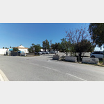 This parking lot at the cemetery is the end of the road for mobile homes.
 [ click for more information ]