GIS24.net
Geographic Information System
POI database from MEINWOMOmaps


Geographic Information System
POI database from MEINWOMOmaps
Pagensand
/
ADDRESS
25371 SeestermüheZum Schallenhaus
WeiterUrl : https:/ / de.wikipedia.org/ wiki/ Pagensand
UrlLoad : https:/ / yes
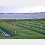
WikiText : Pagensand (von Plattdeutsch: Paag = Wallach) ist eine Elbinsel in der Unterelbe. Sie gehört hauptsächlich zur Gemeinde Seestermühe (Kreis Pinneberg, Schleswig-Holstein), kleinere Flächen auch zu den Gemeinden Haselau (Kreis Pinneberg), Kollmar (Kreis Steinburg) und Neuendorf (Kreis Steinburg). Die Insel ist ca. 5.8 km lang, etwa 1 km breit und 460-520 Hektar groß. Ursprünglich handelte es sich nur um eine große Sandbank am Ostufer der Elbe. Sie wurde etwa seit 1900 als Absetzplatz für ausgebaggerten Elbschlick benutzt, dabei um das etwa fünffache vergrößert und im Niveau erhöht. So entstand eine fruchtbare Kultur- und Wiesenlandschaft.
Click for interactive map
..
Pictures of the Poi and surroundings
.
Things to see in the area
Parkenpkw
[ click for more information ]ParkenPkw
[ click for more information ]Festung Grauerort
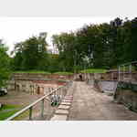 The Grauerort Fortress is a high-wall fort that was built by Prussia between 1868 and 1873 on the Elbe near Stade to protect enemy ships.
 [ click for more information ]
ParkenPkw
[ click for more information ]Kleiner PLatz am Hafen Barnkrug
[ click for more information ]Aussichtspunkt Kreuzdeich
The Kreuzdeich viewpoint is located near Altendeich and Audeich.[ click for more information ]
Segler Combination Pinnau in Schleswig-Holstein
[ click for more information ]To`n Vossbau
Very good local cuisine in a cozy atmosphere..[ click for more information ]
Feuerwehr
[ click for more information ]Penny
Penny Market Stade[ click for more information ]