GIS24.net
Geographic Information System
POI database from MEINWOMOmaps


Geographic Information System
POI database from MEINWOMOmaps
Monts Dore
/
ADDRESS
63240 Mont-DoreCacadogne
WeiterUrl : https:/ / de.wikipedia.org/ wiki/ Monts Dore
UrlLoad : https:/ / yes
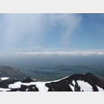
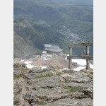
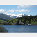
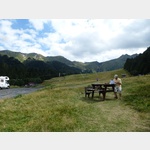
WikiText : Das Massiv der Monts Dore (franz. massif des Monts Dore) liegt im französischen Zentralmassiv der Auvergne im Dpartement Puy-de-Dme. Die Bergkette ist vulkanischen Ursprungs. Die höchsten Erhebungen sind der Puy de la Perdrix (1.824 ,m), Puy de Sancy (1.885 ,m) und Puy Fernand. Diese umgeben hufeisenförmig das nach Norden geöffnete Valle de Chaudefour. Am Eingang des Tales liegt als Ausgangspunkt für Wanderungen eine naturkundliches Informationszentrum. Als weitere vulkanische Attraktion sei auf die Felsenformation Roches Tuilire et Sanadoire hingewiesen. Am Rand des Massivs liegen vulkanische Seen und Maare wie der Badesee Lac Chambon im Nordosten und der Lac Pavin im Südosten. Am Fuß des Puy de la Perdrix liegt auf 1.350 ,m Höhe der Wintersportort Super Besse mit einer modernen Betonarchitektur. Von hier führt eine Gondelseilbahn auf den Gipfel des Puy de la Perdrix.
Click for interactive map
..
Pictures of the Poi and surroundings
.
Things to see in the area
Puy de Sancy 1885 m
[ click for more information ]Puy de Pallaret 1721 m
[ click for more information ]Parkplatz Route des Longes D101
 Le Mont Dore Parking Les Longes V E ( Flot Bleu ) ca.
 [ click for more information ]
Col de la Croix Saint-Robert 1451 m
[ click for more information ]Sonstiges
[ click for more information ]Toilette
[ click for more information ]Parkenpkw
[ click for more information ]Lac des Hermines
[ click for more information ]Parkenpkw
[ click for more information ]Vallee Chaudefour
The hike has a length of approx.[ click for more information ]