GIS24.net
Geographic Information System
POI database from MEINWOMOmaps


Geographic Information System
POI database from MEINWOMOmaps
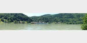
Schlögener Schlinge
/
ADDRESS
 4083 Gemeinde Haibach ob der Donau
Donauradweg
WeiterUrl : https:/ / de.wikipedia.org/ wiki/ Schlögener Schlinge
UrlLoad : https:/ / yes
WikiText : Die Schlögener Schlinge ist eine Donauschlinge im oberen Donautal in Oberösterreich, etwa auf halbem Weg zwischen Passau und Linz (zwischen Stromkilometer 2180,5 und 2186,5). Das südliche Ufer liegt in der Gemeinde Haibach ob der Donau und deren Ortsteil Schlögen, der der Schlinge den Namen verleiht. Im Norden grenzen die Gemeinden Hofkirchen im Mühlkreis mit der Ortschaft Au und Niederkappel mit der Ortschaft Grafenau im Bereich der Donauschlinge an. Der Fluss bahnte sich im Durchbruchstal zwischen Passau und Aschach seinen Weg durch das böhmische Massiv und schnitt den Sauwald ab. Der Durchbruch erfolgt in mehreren Mäandern. An der Schlinge wendet die Donau in einer engen Kehre um 180 Grad von südöstlicher auf nordwestliche Laufrichtung, anschließend zurück Richtung Osten. Das obere Donautal wird oft als der schönste und ursprünglichste Abschnitt der Donau beschrieben, obwohl die Donau hier nicht frei fließt, sondern durch die Donaukraftwerke gezähmt wurde. Die Schlinge liegt noch im Stauraum des Kraftwerkes Aschach. Früher galt die Donauschlinge als eine der gefährlichsten Stellen des Donaulaufes für die Schifffahrt.
Click for interactive map
..
Pictures of the Poi and surroundings
Videos about the Poi and the surrounding area
.
.
Things to see in the area
Ruine Haichenbach
The Haichenbach ruins, also known as Kerschbaumerschlössl, are located in the municipality of Hofkirchen im Mühlkreis in the Rohrbach district in the Mühlviertel in Upper Austria.[ click for more information ]
Inn to the Holy Nicholas
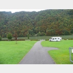 very nice campsite directly on the Danube and the Danube cycle path
usable 1 January - 31 December
[ click for more information ]
Radfähre Au
[ click for more information ]Faehre
The Danube ferry Au-Schlögen operates from April to November[ click for more information ]
Yachthafen Schlögen
[ click for more information ]Freizeitanlage Schlögen
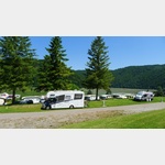 Beautiful location on the Danube, space extends over 3 terraces
is usable April - October
[ click for more information ]
CICONIA Weg
The CICONIA trail offers the opportunity to get to know the Schlögener Donauschlinge and its nature better.[ click for more information ]
Mühlviertler Dom
Open: Mon - Sun: 8 a.m.[ click for more information ]
Pyramide Etzinger Hügel
On the 642 m high Etzinger hill is the Paramide, which is used as a viewing platform and as a meditation pyramid.[ click for more information ]
Marsbach
Marsbach Castle, which was first mentioned in documents in 1075 and is considered the oldest aristocratic residence in the upper Mühlviertel.[ click for more information ]
Donautaler Mostkellerei
The qualified cider sommelier Erich Aumüller has had a cider cellar right next to the Danube since 2007 and offers space for around 50 people for cellar tours and cider tastings.[ click for more information ]
Pfarrkirche
The parish church in Hofkirchen im Mühlkreis is an important religious building in the community.[ click for more information ]