GIS24.net
Geographic Information System
POI database from MEINWOMOmaps


Geographic Information System
POI database from MEINWOMOmaps
Dimmuborgir
/
ADDRESS

WeiterUrl : https:/ / de.wikipedia.org/ wiki/ Dimmuborgir
UrlLoad : https:/ / yes
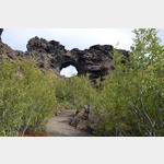
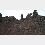
WikiText : Dimmuborgir [d.m b.gi] (isl. dunkle Städte oder dunkle Burgen) ist ein Lavafeld östlich des Sees Mvatn in Island. Die bizarr geformten Steinformationen erinnern an verfallene Ruinen von Burgen und Türmen. In der isländischen Mythologie wird Dimmuborgir als Unterkunftsort von Elfen und Trollen gesehen. Das Lavafeld befindet sich in der vulkanisch aktiven Region des Mvatn, direkt östlich des Sees. Nordöstlich angrenzend liegt der Aschekrater des Vulkans Hverfjall. Die norwegische Symphonic-Black-Metal-Band Dimmu Borgir leitete ihren Bandnamen von der Formation ab.
Click for interactive map
..
Pictures of the Poi and surroundings
.
Things to see in the area
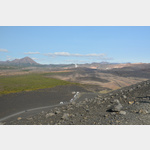
Lavafelder
 Very well landscaped area with hiking trails
[ click for more information ]
Dimmuborgir / Kaffi Borgir
Lava fields worth seeing, parking lot with café and souvenir shop[ click for more information ]
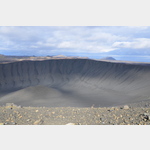
Hverfjyall
 2228011_Beschreibung
[ click for more information ]
Grjotagja
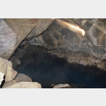 In a large crevice there is a thermal spring that used to be used for bathing.
 [ click for more information ]