GIS24.net
Geographic Information System
POI database from MEINWOMOmaps


Geographic Information System
POI database from MEINWOMOmaps
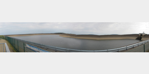
Vorsperre Gräftiegelsperre
/
ADDRESS
98749 GoldisthalL 1112
WeiterUrl : https:/ / de.wikipedia.org/ wiki/ Pumpspeicherwerk Goldisthal
UrlLoad : https:/ / yes
WikiText : Das Pumpspeicherwerk (PSW) Goldisthal ist ein Pumpspeicherkraftwerk im Thüringer Schiefergebirge am Oberlauf der Schwarza zwischen Goldisthal und Scheibe-Alsbach und wurde im Jahr 2003 in Betrieb genommen. Es ist mit einer Leistung von 1.060 ,MW das größte Wasserkraftwerk Deutschlands und eines der größten Europas. Auf Grund intensiver Auseinandersetzungen mit dem Naturschutzverband BUND hat der Bau indirekt zur Gründung der Naturstiftung David geführt.
Click for interactive map
..
Pictures of the Poi and surroundings
.
Things to see in the area
TouristInfo
[ click for more information ]ParkenAll
[ click for more information ]Parkplatz, auch zum Übernachten
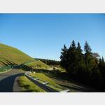 Parking lot to the viewing platform from the upper reservoir
is open January - December
[ click for more information ]
Farmdenkopfbecken
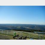 The upper water reservoir from the pumped storage plant is the Farmdenkopf basin.
 [ click for more information ]
GroÃer Langebachsberg
Thuringian Forest, 723 m[ click for more information ]
Schwarza Stausee
Es ist der Untersee vom Pumpspeicherwerk Goldistal[ click for more information ]
Dreistromstein
Here is the triple watershed between the Elbe, Weser and Rhine.[ click for more information ]
Goldberg
Thuringian Forest, 736 m[ click for more information ]
Kleiner Sauberg
Thuringian Forest, 751 m[ click for more information ]
Bleßbergturm
The observation tower built in 1902 on the 867 m high Bleßberg was demolished in 1972 by the GDR authorities.[ click for more information ]
Itz
After 80 km, the Itz flows into the Main near Ratteldorf.[ click for more information ]