GIS24.net
Geographic Information System
POI database from MEINWOMOmaps


Geographic Information System
POI database from MEINWOMOmaps
Engelthaler Forst
/
ADDRESS
Leinburg, PühlhofWeiterUrl : https:/ / de.wikipedia.org/ wiki/ Engelthaler Forst
UrlLoad : https:/ / yes
WikiText : Der Engelthaler Forst ist ein 2,42 km großes gemeindefreies Gebiet im mittelfränkischen Landkreis Nürnberger Land. Der Forst ist südlich von Engelthal, westlich von Offenhausen und östlich von Leinburg gelegen. Der Nonnenberg ist mit 579 m die höchste Erhebung im gemeindefreien Gebiet.
Click for interactive map
..
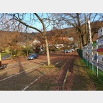
Pictures of the Poi and surroundings
.
Things to see in the area
Burgstall Ödes Schloss
[ click for more information ]Waldparkplatz Engelthal
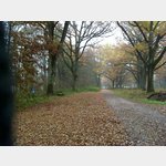 Quiet secluded forest park in an old oak grove - not quite level - from here you can go hiking - for example stone gutter - see walking signs on the site
is open January - December
[ click for more information ]
Parkplatz Entenberg
[ click for more information ]Biergarten
Great inn and beer garden for hikes in the area[ click for more information ]
Naturbad Weissenbrunn
 A parking lot at a beautifully landscaped natural pool, it´s worth it How to get there: From Weissenbrunner Hauptstr.
 [ click for more information ]
St. Ottmar und Ottilie Kapelle
[ click for more information ]Schloss Henfenfeld
[ click for more information ]Restaurant Wirtshaus Zum Herzog Bahnhofstr.
[ click for more information ]
[ click for more information ]
sonstiges
Mercedes garage[ click for more information ]
Shell gas station
[ click for more information ]
[ click for more information ]
Shell gas station
[ click for more information ]
[ click for more information ]