GIS24.net
Geographic Information System
POI database from MEINWOMOmaps


Geographic Information System
POI database from MEINWOMOmaps
Schloss Brederode
/
ADDRESS
WeiterUrl : https:/ / de.wikipedia.org/ wiki/ Schloss Brederode
UrlLoad : https:/ / yes
WikiText : Das Schloss Brederode ( niederländisch: Rune van Brederode) ist die teilweise wiederaufgebaute Ruine eines aus dem Mittelalter stammenden Schlosses südwestlich des Dorfes Santpoort in der Gemeinde Velsen im Norden der Niederlande. Ende des 19.Jahrhunderts stand die Ruine als eines der ersten Gebäude unter Denkmalschutz und wurde fast vollständig wiederaufgebaut. Die Ruine liegt an einer Küstendüne, deren Ausläufer in Richtung Südwest-Nordost in ein Moor mündet, wo die Ruine liegt. Das Schloss wurde auf solidem Grund errichtet und ist auf drei Seiten vom Moor umgeben. Im Norden grenzt die Ruine an einen Fluss. Die Vordergebäude wurden höchstwahrscheinlich in den Jahren von 1225 bis 1245 und das Hauptschloss im Jahr 1282 von William dem I., Herr von Brederode erbaut.
Click for interactive map
..
Pictures of the Poi and surroundings
.
Things to see in the area
Ruïne van Brederode
[ click for more information ][ click for more information ]
Station Santpoort-Noord
[ click for more information ][ click for more information ]
[ click for more information ]
Allgemeiner Parkplatz
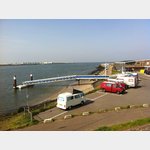
[ click for more information ]Wohnmobil-Tagesparkplatz am Kanaldeich
Right by the ferry.[ click for more information ]
Grode of St. Bavokerk
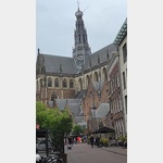 St.
St. [ click for more information ]
Wohnmobil-Tagesparkplatz Velsen
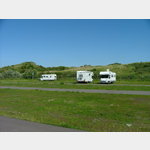 Official car park only, parking fee 1.80 EUR / hour.
 [ click for more information ]
Parkplatz Reyndersweg
 The old village church of Velsen is worth seeing.
 [ click for more information ]