GIS24.net
Geographic Information System
POI database from MEINWOMOmaps


Geographic Information System
POI database from MEINWOMOmaps
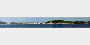
Canyamel
/
ADDRESS
WeiterUrl : https:/ / de.wikipedia.org/ wiki/ Canyamel
UrlLoad : https:/ / yes
WikiText : Canyamel ist ein kleiner Urlaubsort an der Ostküste der Baleareninsel Mallorca, sechs Kilometer südlich von Cala Rajada und unweit der Tropfsteinhöhlen Coves dArt . Verwaltungstechnisch gehört er zur Gemeinde Capdepera. Der Name leitet sich von einer Konzession für den Zuckerrohranbau (span. cana de miel, katalanisch canya de mel(wörtl.: Rohr aus Honig (Canya=Rohr, Mel=Honig) ab, die Johann II. (Aragn) dem lokalen Gutsbesitzer 1428 erteilte. Canyamel ist zu beiden Seiten von bewaldeten, 200 bis 300 Meter hohen Hügeln umgeben, die nach Südwesten in das Cap des Pinar o des Raix, und nach Nordosten, wo sich auch die Tropfsteinhöhlen befinden, in das Cap Vermell münden.
Click for interactive map
..
Pictures of the Poi and surroundings
.
Things to see in the area
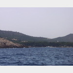
Ankerbucht
 Cala de Canamel Cala Canamel in the Anse de Canamel is a wide open bay where you can anchor on 3-4m sand in front of the sandy beach.
 [ click for more information ]
Haus
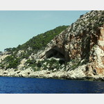
[ click for more information ]spanien,Cuevas de Arta
[ click for more information ]Cap Vermell
[ click for more information ]Canyamel Golf Club
[ click for more information ]LandHaus
[ click for more information ]LandHaus
[ click for more information ]Cabo del Pinar
[ click for more information ]Cala s´en Font / Cala de San Geroni
 Located south of Cala Ratjada and is a hotel bay with several arms.
 [ click for more information ]