GIS24.net
Geographic Information System
POI database from MEINWOMOmaps


Geographic Information System
POI database from MEINWOMOmaps
Nymindegab
/
ADDRESS

WeiterUrl : https:/ / de.wikipedia.org/ wiki/ Nymindegab
UrlLoad : https:/ / yes
WikiText : Nymindegab ist ein ehemaliges Fischerdorf oberhalb der Steilküste am südlichen Ende des Ringkbingfjords in Dänemark, heute Zentrum eines Feriengebiets. Verlässt man Nymindegab in westlicher Richtung, erreicht man das Gebiet Bjerregrd, in dem sich ein großes Areal mit Ferienhäusern befindet. Sehenswert in der Umgebung ist das Vogelschutzgebiet Tipperne, sowie das Walskelett, das in einem eigenen Gebäude direkt neben der Durchgangsstraße aufgestellt ist und dort besichtigt werden kann. Schau- und Texttafeln informieren ausführlich über Pottwale im Allgemeinen und den hier ausgestellten Wal im Besonderen. Bei der Seenotrettungsstation in Nymindegab kann man Dänemarks ältestes Rettungsboot besichtigen. Es war von 1966 bis 1977 im Nationalmuseum in Kopenhagen ausgestellt, befindet sich aber heute wieder in Nymindegab.
Click for interactive map
..
Pictures of the Poi and surroundings
.
Things to see in the area
ParkenAll
[ click for more information ]Nymindegab Museum
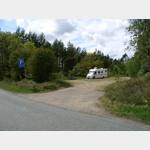
[ click for more information ]Familie Camping Nymindegab
The sites are located in the dunes area and also in the meadowusable 26 March - 27 September
[ click for more information ]
ParkenWander
[ click for more information ]Parkenwander
[ click for more information ]Gødelen
[ click for more information ]Parkenwander
[ click for more information ]Camping Vesterlund
The site is not far from the Tipperne bird reserveopen 27 March - 18 October
[ click for more information ]
Kirkeflod
[ click for more information ]Parkenwander
[ click for more information ]TouristInfo
Interactive tourist info screen wall in Bjerregards grocery store[ click for more information ]
Parkplatz Vaernsande
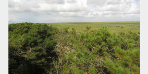
 In a bird sanctuary, with a lookout tower, also suitable for cycling.
 [ click for more information ]