GIS24.net
Geographic Information System
POI database from MEINWOMOmaps


Geographic Information System
POI database from MEINWOMOmaps
Schrems bei Frohnleiten
/
ADDRESS
 8130 Schrems bei Frohnleiten
Triebweg
WeiterUrl : https:/ / de.wikipedia.org/ wiki/ Schrems bei Frohnleiten
UrlLoad : https:/ / yes
WikiText : Schrems bei Frohnleiten ist eine Gemeinde mit ca. 550 Einwohnern im Norden des Bezirks Graz-Umgebung in der Steiermark. Schrems bei Frohnleiten liegt ca. 3 km östlich von Frohnleiten im Grazer Bergland in der Oststeiermark. Die höchsten Berge im Gemeindegebiet sind der Hochtrötsch (1.239 m) und der Gschieskogel (1.142 m). Die Gemeinde liegt am Fuße des Rechberg-Passes. Katastralgemeinden sind Gschwendt und Schrems.
Click for interactive map
..
Pictures of the Poi and surroundings
.
Things to see in the area
Hochtrötsch 1239 m
[ click for more information ]Rinnweberkogel 1041 m
[ click for more information ]Schwarzkogel 906 m
[ click for more information ]Fontaine im Volkshauspark
[ click for more information ]Billa
[ click for more information ]Fragnerberg 1109 m
[ click for more information ]Spar
[ click for more information ]Weizentalerweg
The Weizentalerweg to the Drachenhöhle and the Röthlstein.[ click for more information ]
Parkplatz in Frohnleiten
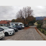 In this car park in Frohnleiten, 2 overnight stays with the mobile home were without any problems.
 [ click for more information ]
Drachenhöhle
The Dragon Cave is not accessible! Very nice but steep circular hike, which is partially secured with chains.[ click for more information ]