GIS24.net
Geographic Information System
POI database from MEINWOMOmaps


Geographic Information System
POI database from MEINWOMOmaps
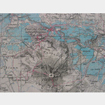
Valchava
/
ADDRESS

WeiterUrl : https:/ / de.wikipedia.org/ wiki/ Valchava
UrlLoad : https:/ / yes
WikiText : Valchava (deutsch und bis 1943 offiziell Valcava) war bis zum 31. Dezember 2008 eine politische Gemeinde im Kreis Val Müstair im Bezirk Inn des Kantons Graubünden in der Schweiz. Per 1. Januar 2009 hat Valchava mit den übrigen Schweizer Gemeinden der Talschaft (Fuldera, Lü, Müstair, Santa Maria Val Müstair und Tschierv) zur Gemeinde Val Müstair fusioniert. Der Name Valchava bedeutet Tiefes Tal. Beschreibung: In Gold (Gelb) ein gestürzter blauer Sparren. Das Wappen versinnbildlicht den Gemeindenamen gleich zweifach: der Sparren steht einmal für den Anfangsbuchstaben der Gemeinde und gleichzeitig auch für den Begriff "Val".
Click for interactive map
..
Pictures of the Poi and surroundings
.
Things to see in the area
Raiffeisen Valchava
[ click for more information ]Volg
[ click for more information ]Volg
[ click for more information ]sonstiges
[ click for more information ]Campeggio Pe da Munt
Idyllic ACSI campsite on the edge of the forest with everything you needusable 21 May - 4 October
[ click for more information ]
Center da sandà Val Müstair
Phone: 081 851 61 00 Fax: 081 851 61 51[ click for more information ]
Raiffeisen Terzal d´Aint - Fuldera
[ click for more information ]Cascada da Pisch
Waterfall in Val Müstair[ click for more information ]
sonstiges
[ click for more information ]Bio Hof Puntetta
individual llama treks[ click for more information ]
maxbreite-m
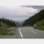
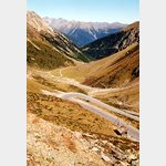 Narrow mountain road, dark, narrow tunnels on the descent to Italy!
[ click for more information ]