GIS24.net
Geographic Information System
POI database from MEINWOMOmaps


Geographic Information System
POI database from MEINWOMOmaps
Senèdes
/
ADDRESS

WeiterUrl : https:/ / de.wikipedia.org/ wiki/ Senèdes
UrlLoad : https:/ / yes
WikiText : Sendes ist eine politische Gemeinde im District de la Sarine (deutsch: Saanebezirk) des Kantons Freiburg in der Schweiz. Sendes liegt auf 748 ,m ,ü. ,M., 7 km südlich der Kantonshauptstadt Freiburg (Luftlinie). Das Bauerndorf erstreckt sich am Südhang des Bois dAmont über dem Tal von Sendes, in der voralpinen Hügelzone des Freiburger Mittellandes. Die Fläche des nur gerade 0.5 km grossen Gemeindegebiets umfasst einen Abschnitt der voralpinen Hügellandschaft östlich des Saanegrabens. Der Gemeindeboden erstreckt sich von der Talmulde des Dorfbachs nordwärts über den Hang von Sendes bis auf die Höhe westlich des Bois dAmont, wo mit 820 ,m ,ü. ,M. der höchste Punkt der Gemeinde erreicht wird. Von der Gemeindefläche entfielen 1997 16 ,% auf Siedlungen, 10 ,% auf Wald und Gehölze und 74 ,% auf Landwirtschaft.
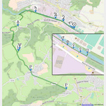
Click for interactive map
..
Pictures of the Poi and surroundings
Videos about the Poi and the surrounding area
.
.
Things to see in the area
Autowaschanlage
[ click for more information ]Sonstiges
[ click for more information ]Raiffeisen Treyvaux
[ click for more information ]Coop
[ click for more information ]ParkenPkw
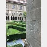 Monastery of Hauterive Route d´Hauterive 21-27, 1725 Hauterive, Suisse
[ click for more information ]
Wanderparkplatz Chemin pédestre
[ click for more information ]Autowaschanlage
[ click for more information ]Elephant Bleu
[ click for more information ]Planetenweg Marly
 The sun is on the railway bridge at the Corbaroche Stadium 46.
 [ click for more information ]
Buvette du Gros Cousimbert
Übernachtungsmöglichkeit[ click for more information ]