GIS24.net
Geographic Information System
POI database from MEINWOMOmaps


Geographic Information System
POI database from MEINWOMOmaps
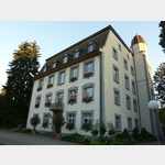
Schupfart
/
ADDRESS

WeiterUrl : https:/ / de.wikipedia.org/ wiki/ Schupfart
UrlLoad : https:/ / yes
WikiText : Schupfart (schweizerdeutsch: [pft]) ist eine Einwohnergemeinde im Bezirk Rheinfelden des Schweizer Kantons Aargau. Sie liegt im Zentrum der Region Fricktal, etwas mehr als drei Kilometer südlich der Grenze zu Deutschland. Das Haufendorf liegt in einer flachen Mulde am oberen Ende des Fischingertals. Im nördlichen und im westlichen Teil des Gemeindegebiets erstrecken sich die flachen und ausgedehnten Hochebenen des Eikerbergs (504 ,m ,ü. ,M.) bzw. des Hellikerbergs (541 ,m ,ü. ,M.). Im Gegensatz zum unteren Teil des Fischingertals ist der bergang zu den Hochflächen leicht ansteigend. Die Anstiege zum Wolberg (556 ,m ,ü. ,M.) im Osten und insbesondere zum Thiersteinberg (749 ,m ,ü. ,M.) sind hingegen stellenweise äusserst steil. Die Fläche der Gemeinde beträgt 705 Hektaren, davon sind 233 Hektaren bewaldet und 49 Hektaren überbaut. Der höchste Punkt befindet sich auf 749 Metern an der Geländekante des Thiersteinbergs, die tiefste Stelle liegt auf 408 Metern am Fischingerbach. Nachbargemeinden sind Münchwilen und Eiken im Norden, Frick im Nordosten, Gipf-Oberfrick im Südosten, Wegenstetten im Südwesten, Hellikon im Westen sowie Obermumpf im Nordwesten.
Click for interactive map
..
Pictures of the Poi and surroundings
Videos about the Poi and the surrounding area
.

.
Things to see in the area
Volg
with postal agency[ click for more information ]
Volg
with postal agency[ click for more information ]
Volg
with postal agency[ click for more information ]
Wanderweg Rhein und Berge
It then goes through the city up to the large game reserve and the view at the Röthekopf.[ click for more information ]
sonstiges
Ruedi Rüssel gas station at AD Garage Hasler[ click for more information ]
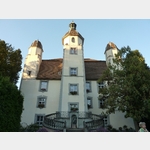
St.Fridolinsmünster
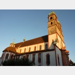 The Fridolinsmünster, the symbol of the town of Bad Säckingen, was dedicated to St.
 [ click for more information ]
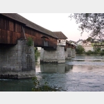
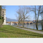
Wohnmobilparkplatz beim THW
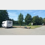 Parking directly on the Rhine, directly behind the THW and fire station.
[ click for more information ]
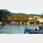
Gallusturm
Gallusturm 1343 Rheinallee 1773 it was built as a breakwater, the floodwaters of the Rhine had hit the island town.[ click for more information ]
TouristInfo
Tourismus GmbH Bad Säckingen[ click for more information ]
Netto
Net brands discount Bad Säckingen[ click for more information ]
Ziegeleiweiher
Er liegt auf der Westseite des Bahnhofs auf 354m.[ click for more information ]
Kaufland
Kaufland market in Bad Saeckingen[ click for more information ]
Norma
Norma market in Bad Sackingen[ click for more information ]
Neukauf
New purchase market Bad Säckingen[ click for more information ]
Restaurant "Zum Hirschen"
Very good restaurant with many seasonal dishes/products.[ click for more information ]
Penny
Penny Market Bad Sackingen[ click for more information ]