GIS24.net
Geographic Information System
POI database from MEINWOMOmaps


Geographic Information System
POI database from MEINWOMOmaps
Schnaus
/
ADDRESS

WeiterUrl : https:/ / de.wikipedia.org/ wiki/ Schnaus
UrlLoad : https:/ / yes
WikiText : Schnaus ist eine politische Gemeinde im Kreis Ilanz im Bezirk Surselva des Kantons Graubünden in der Schweiz. Beschreibung: In Schwarz drei schräglinks gestellte silberne (weisse) Pfeile. Der Pfeil verweist auf den heiligen Sebastian, dem ursprünglich die örtliche Kirche geweiht war. Die Dreizahl der Pfeile steht für den historischen Gemeindeverbund von Schnaus mit Ruschein und Ladir. Die Gemeinde liegt auf der linken Seite des Vorderrheins westlich von Ilanz. Sie besteht aus zwei Teilen. Der untere südliche Teil reicht vom Vorderrhein bis hinauf nach Mulin und reicht von 700 m bis auf eine Höhe von 1220 m. Der obere nördliche Teil, die Alp da Schnaus reicht von 1700 m bis hinauf zum Crest da Tiarms (2412 ,m ,ü. ,M.) und besteht zum grossen Teil aus Gebirge und Wald. Die beiden Teile sind getrennt durch einen Streifen Gemeindegebiet von Ruschein.
Click for interactive map
..
Pictures of the Poi and surroundings
Videos about the Poi and the surrounding area
.
.
Things to see in the area
Parkenwander
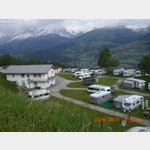
[ click for more information ]Camping Surcuolm
 Open all year, ACSI card is accepted
is usable January - December
[ click for more information ]
ParkenAll
[ click for more information ]Einkaufsparkplatz
[ click for more information ]einkaufen
[ click for more information ]Coop
[ click for more information ]Aldi
[ click for more information ]Autowaschanlage
[ click for more information ]Friedhof St. Josef
[ click for more information ]Friedhof St. Josef
[ click for more information ]Rufalipark
Play paradise, tennis, restaurant[ click for more information ]