GIS24.net
Geographic Information System
POI database from MEINWOMOmaps


Geographic Information System
POI database from MEINWOMOmaps
Ramosch
/
ADDRESS

WeiterUrl : https:/ / de.wikipedia.org/ wiki/ Ramosch
UrlLoad : https:/ / yes
WikiText : Ramosch (deutsch und bis 1943 offiziell Remüs) ist eine politische Gemeinde im gleichnamigen Kreis, Bezirk Inn des Schweizer Kantons Graubünden. Beschreibung: In Silber (Weiss) ein schwarzes, rot bewehrtes Einhorn. bernahme des überlieferten Siegelbildes der Gemeinde. Das Einhorn ist Wappenbild der Herren von Remüs, Ministerialen des Bischofs von Chur, und erscheint ebenfalls in einem Feld des Wappens der Familie Planta, die Rechte in Ramosch besass. Ramosch ist ein Ort im Unterengadin, der auf ca. 1236 ,m ,ü. ,M. liegt. Zu Ramosch gehören Vn , Seraplana und Raschvella. Ebenfalls zu Ramosch gehört der obere Teil des Fimbatals (rätoroman. Val Fenga) im ansonsten österreichischen Paznauntal.
Click for interactive map
..
Pictures of the Poi and surroundings
.
Things to see in the area
Florinuskirche
[ click for more information ]Volg
Volg branch with postal agency[ click for more information ]
Reformierte Kirche
[ click for more information ]Skulpturenweg Sur En
In 1994 the first sculpture symposium was held at the Sur En / Sent campsite.[ click for more information ]
Campingplatz Sur En
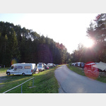 Beautifully located campsite on the Inn river, rope park nearby
 is usable January - December
[ click for more information ]
Skulpturenweg Scuol
 Der rund 5 km lange Rundweg im Wald führt am Campingplatz Sur En (1709905) vorbei und die Tour kann man auch dort beginnen oder beenden.
 [ click for more information ]
Seilpark Engadin
Various rope park options.[ click for more information ]