GIS24.net
Geographic Information System
POI database from MEINWOMOmaps


Geographic Information System
POI database from MEINWOMOmaps
Le Frasnois
/
ADDRESS
39130 Le FrasnoisD 75
WeiterUrl : https:/ / de.wikipedia.org/ wiki/ Le Frasnois
UrlLoad : https:/ / yes
WikiText : Le Frasnois ist eine Gemeinde im französischen Dpartement Jura in der Region Franche-Comt. Le Frasnois liegt auf 792 ,m ,ü. ,M., etwa zwölf Kilometer südlich der Stadt Champagnole (Luftlinie). Das Dorf erstreckt sich im Jura, auf einer Hochfläche zwischen den Seen Lac de la Motte im Süden und Lac de Narlay im Norden, am Rand der ausgedehnten Waldhöhen des Bois sur le Lac und des Bois de Banc. Die Fläche des 14,56 ,km großen Gemeindegebiets umfasst einen Abschnitt des französischen Juras. Der zentrale Teil wird von der leicht gewellten Hochfläche von Le Frasnois eingenommen, die durchschnittlich auf 790 ,m ,ü. ,M. liegt. Auf dieser Kalkhochfläche befinden sich in Mulden, die durch Mergel- und Tonschichten eiszeitlicher Gletscherablagerungen abgedichtet wurden, verschiedene Seen: der Lac du Petit-Maclu, der Lac du Grand-Maclu und der Lac de la Motte, die alle zum Einzugsgebiet des Hrisson gehören, sowie der Lac de Narlay, der unterirdisch entwässert wird. stlich der Lacs de Maclu steigt der Hang steil an, und auf der Hochfläche des Bois de Ban wird mit 930 ,m ,ü. ,M. die höchste Erhebung von Le Frasnois erreicht. Nach Nordosten reicht der Gemeindeboden auf den Höhenrücken des Mont des Ifs (889 ,m ,ü. ,M.).
Click for interactive map
..
Pictures of the Poi and surroundings
Videos about the Poi and the surrounding area
.
.
Things to see in the area
Echter Stellplatz
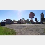 in the village square, very quiet, opposite the church square
is open January - December
[ click for more information ]
Parkplatz PKW
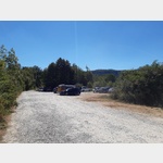 PP on a small bathing bay with lawn and dock for fishing boats/
[ click for more information ]
ParkenPkw
PP at the lake.[ click for more information ]
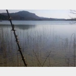
Lac de la Motte Ou d´Llay
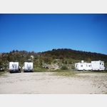
[ click for more information ]Camping Lac De Narlay
Camping with mixed audience, very nice location right on the lake, no disposal facility for campers, the operator recommends to dispose of the toilet and the gray water in the normal toiletsis usable 19 April - 25 September
[ click for more information ]
Le Grand Maclu Lac
[ click for more information ]Lac de Narlay
[ click for more information ]Lac du Vernois
[ click for more information ]Pic de l´ Aigle (993 m)
With a height of 993 meters, the Pic de l´Aigle does not belong in the front line of the panoramic mountains.[ click for more information ]
La Fromagerie
on the D39is open January - December
[ click for more information ]
Wanderung zum Pic de l´ Aigle
Anyone who would like to see the lakes in the area between the towns of La Fromagerie and Le Frasnois from above and also has a fable for distant views should climb the Pic de l´Aigle.[ click for more information ]
Pic de l´ Aigle
 Trail parking lot in a beautiful location
usable January - December
[ click for more information ]
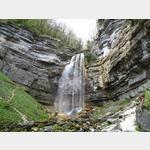
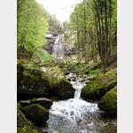
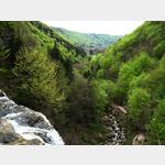
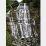
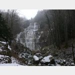
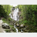
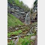
Cascades du Hérisson
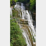 The outlets of the Bonlieu and Ilay lakes feed the Hérisson river near the village of La Fromagerie, which forms 31 waterfalls of different types in a steep valley between this village and the Lac du Val, which can be visited on a 3-hour hike.
 [ click for more information ]
Information office and a kind of natural history museum of the Cascades du Herisson.
[ click for more information ]
[ click for more information ]