GIS24.net
Geographic Information System
POI database from MEINWOMOmaps


Geographic Information System
POI database from MEINWOMOmaps
Udler
/
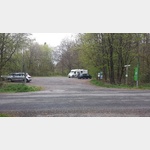
ADDRESS
54552 UdlerHolzmaarstraße
WeiterUrl : https:/ / de.wikipedia.org/ wiki/ Udler
UrlLoad : https:/ / yes
WikiText : 298 (31. ,Dez. ,2008)[1] Udler ist eine Ortsgemeinde im Landkreis Vulkaneifel in Rheinland-Pfalz. Sie gehört der Verbandsgemeinde Daun an. Udler, früher auch Odeler und Oudler, gehörte seit 1357 zum Kurtrierischen Amt Daun.[2] Nach der bernahme des Rheinlandes, zu dem Udert damals zählte, durch Preußen kam der Ort 1815/1816 zu dem damals neu gebildeten Kreis Daun und gehörte zur Bürgermeisterei Gillesfeld, Anfang des 19. Jahrhunderts hatte der Ort 188 Einwohner, die in 33 Häusern lebten.[3]
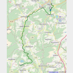
Click for interactive map
..
Pictures of the Poi and surroundings
Videos about the Poi and the surrounding area
.
.
Things to see in the area
Parkplatz Autobahn
Parking lot Udler A 1 Udler[ click for more information ]
Dürres Maar
Dry maar next to the water-bearing Holzmaar.[ click for more information ]
Parkplatz Autobahn
Schalkenmehren A 1 Mehren car park[ click for more information ]
Wohnmobilparkplatz Gillenfeld
 nice place on the edge of Holzmaar
is open January - December
[ click for more information ]
Swimming area Schalkenmehrener Maar, 54552 Schalkenmehren, Germany
[ click for more information ]
[ click for more information ]
Dronketurm
The 11 m high tower stands on the 561 m high Mouse Mountain.[ click for more information ]
ParkenPkw
Gemündener Maar car park, 54550 Daun, Germany[ click for more information ]
Vulcano Infoplattform
In 2003, the 28 m high tower was built from Douglas fir trunks.[ click for more information ]
Kreuzweg zum Kloster Buchholz
Vorbei an den 14 Stationen hinauf zum Kloster und der Kirche Mariä Heimsuchung Buchholz[ click for more information ]
Kosmosradweg Kyll
 The sun, in the spa gardens of Daun - Mercury - Venus - Earth - Mars, he too is still in the spa gardens.
 [ click for more information ]
Planetenweg Daun
It runs on the Kosmosradweg Kleine Kyll[ click for more information ]