GIS24.net
Geographic Information System
POI database from MEINWOMOmaps


Geographic Information System
POI database from MEINWOMOmaps
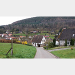
Nothweiler
/
ADDRESS
76891 NothweilerHauptstraße
WeiterUrl : https:/ / de.wikipedia.org/ wiki/ Nothweiler
UrlLoad : https:/ / yes
WikiText : 164 (31. ,Dez. ,2008)[1] Nothweiler ist eine Ortsgemeinde der Verbandsgemeinde Dahner Felsenland im Landkreis Südwestpfalz in Rheinland-Pfalz (Deutschland). Nothweiler liegt im Dahner Felsenland unmittelbar an der Grenze zum französischen Elsass. Die Landschaft gehört zum Naturpark Pfälzerwald.
Click for interactive map
..
Pictures of the Poi and surroundings
.
Things to see in the area
Parkplatz Lembacher Straße
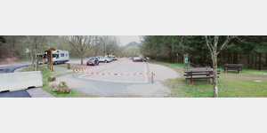 Well-frequented place on weekends in the hiking season.
 [ click for more information ]
Der 4 Burgen Weg
 About 15 km long hike with a total ascent of about 600 meters.
 [ click for more information ]
Kühnenkopf 530 m
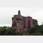
[ click for more information ]Wegelnburg
[ click for more information ]Burgruine Wegelenburg
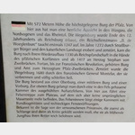 The Wegelenburg is the highest in the Palatinate.
 [ click for more information ]
Burg Loewenstein
[ click for more information ]Hohenburg
[ click for more information ]Hotel-Restaurant Gimbelhof 67510 Lembach A restaurant in the middle of the forest with a beautiful view of Fleckenstein Castle.
[ click for more information ]
[ click for more information ]
Tankstelle Bundenthal
Brennstoffe Köhlerbesonders preisgünstige Tankstelle, welche aber nicht im Tankstellenverbund für Onlinepreisanzeige sind.Hier tanken die Einheimischen und Bauern[ click for more information ]
Chateau de Fleckenstein
 Fleckenstein Castle is a medieval castle ruin that can also be visited.
 [ click for more information ]