GIS24.net
Geographic Information System
POI database from MEINWOMOmaps


Geographic Information System
POI database from MEINWOMOmaps
Laufeld
/
ADDRESS
54533 LaufeldWeierbergstraße
WeiterUrl : https:/ / de.wikipedia.org/ wiki/ Laufeld
UrlLoad : https:/ / yes
WikiText : 501 (31. ,Dez. ,2008)[1] Laufeld in der Eifel ist eine Ortsgemeinde in der Verbandsgemeinde Manderscheid im Landkreis Bernkastel-Wittlich in Rheinland-Pfalz. Die Laufelder Kultur (Hallstatt C, 700 vor Chr.) hat ihren Namen nach einem großen Gräberfeld, das bei Laufeld gefunden worden war.
Click for interactive map
..
Pictures of the Poi and surroundings
.
Things to see in the area
Shell
2235241_Beschreibung[ click for more information ]
Parkplatz Autobahn
Parking Eifel A 1 Niederöfflingen[ click for more information ]
Parkplatz Autobahn
Rest area Eifel A 1 Niederöfflingen[ click for more information ]
Total
2235242_Beschreibung[ click for more information ]
Kreuzweg zum Kloster Buchholz
Vorbei an den 14 Stationen hinauf zum Kloster und der Kirche Mariä Heimsuchung Buchholz[ click for more information ]
Kloster Buchholz
[ click for more information ]Kreuzweg zum Kloster Buchholz
[ click for more information ]Mariä Buchholz
[ click for more information ]Dürres Maar
Dry maar next to the water-bearing Holzmaar.[ click for more information ]
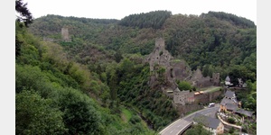
Niederburg
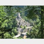 the lower of the two Manderscheider castles
[ click for more information ]