GIS24.net
Geographic Information System
POI database from MEINWOMOmaps


Geographic Information System
POI database from MEINWOMOmaps
Dockendorf
/
ADDRESS
DockendorfHauptstraße
WeiterUrl : https:/ / de.wikipedia.org/ wiki/ Dockendorf
UrlLoad : https:/ / yes
WikiText : 212 (31. ,Dez. ,2008)[1] Dockendorf ist ein Ortsgemeinde im Eifelkreis Bitburg-Prüm in Rheinland-Pfalz. Sie gehört der Verbandsgemeinde Bitburg-Land an. Die Ortschaft liegt in der Südeifel, etwa 10 ,km südwestlich der Kreisstadt Bitburg. Sie ist eingebettet in den Westrand des Nimstales und wird von einem in die Nims mündenden Bach durchflossen. Der höchste Punkt innerhalb des Gemeindegebietes ist der Großenbüsch auf 379 ,m ,ü. ,NN, der niedrigste Bodenpunkt wird mit 225 ,m ,ü. ,NN an der Dockendorfer Mühle erreicht. Mit 60 ,% wird ein vergleichsweise großer Anteil des 5,82 ,km großen Gemeindegebietes landwirtschaftlich genutzt, 30 ,% sind von Wald bestanden.
Click for interactive map
..
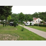
Pictures of the Poi and surroundings
.
Things to see in the area
Atsuo Okamoto: Unit A.LB. 03 s/1.25 co
[ click for more information ]Schloss Wolsfeld
[ click for more information ]Schloss Wolsfeld
[ click for more information ]Albert Hettinger : Verschiebung oder Die unerklärliche Leichtigkeit des Seins
[ click for more information ]Wanderparkplatz
[ click for more information ]Wanderparkplatz
Es gibt einen Mülleimer, ansonsten sehr einsam, zum wandern ideal, zum übernachten möglich wenn man Einsamkeit liebt.[ click for more information ]
Daniel Bragoni : Insieme
[ click for more information ]Friedhof
[ click for more information ]Mark Lorenz : In-Con-tained
[ click for more information ]Köhler-Stuben
 Two-part gastronomy: bar/pizzeria and restaurant.
 [ click for more information ]