GIS24.net
Geographic Information System
POI database from MEINWOMOmaps


Geographic Information System
POI database from MEINWOMOmaps
Osterheide
/
ADDRESS
29683 Osterheide, gemfr. BezirkPanzerringstraße
WeiterUrl : https:/ / de.wikipedia.org/ wiki/ Osterheide
UrlLoad : https:/ / yes
WikiText : 802 (31. ,Dez. ,2008)[1] Die Osterheide ist ein bewohnter gemeindefreier Bezirk im Landkreis Soltau-Fallingbostel am Südrand der Lüneburger Heide in Niedersachsen, etwa zehn Kilometer südlich des Naturparks Lüneburger Heide. Das 177,99 ,km große Gebiet hat 802 Einwohner (Stand 31. Dezember 2008). Sitz der Verwaltung ist das Dorf Oerbke, weitere Dörfer sind Ostenholz und Wense. Der Bezirk Osterheide bildet gemeinsam mit dem Bezirk Lohheide den Truppenübungsplatz Bergen-Hohne.
Click for interactive map
..
Pictures of the Poi and surroundings
.
Things to see in the area
Camping Böhmeschlucht
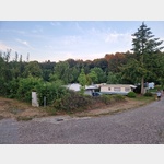 The campsite is located on the banks of the Böhme
open 1 January - 31 December
[ click for more information ]
Bahnhof
[ click for more information ]Stadtapotheke
[ click for more information ]Freilichtmuseum Hof der Heidmark
[ click for more information ]Kur-Apotheke
[ click for more information ]Restaurant McDonalds
[ click for more information ]REWE
[ click for more information ]Getränkemarkt
[ click for more information ]TouristInfo
Tourist Information Bad Fallingbostel[ click for more information ]
Bäcker
[ click for more information ]Aral
Gas station Aral Bad Fallingbostel Westendorfer Strasse 30[ click for more information ]