GIS24.net
Geographic Information System
POI database from MEINWOMOmaps


Geographic Information System
POI database from MEINWOMOmaps
Toila
/
ADDRESS
 41702 Toila vald
Lepa
WeiterUrl : https:/ / de.wikipedia.org/ wiki/ Toila
UrlLoad : https:/ / yes
WikiText : Toila ist eine Landgemeinde im estnischen Kreis Ida-Viru mit einer Fläche von 159,66 km. Sie hat 2324 Einwohner (2005). Die Gemeinde Toila liegt am Finnischen Meerbusen mit seiner beeindruckenden Steilküste. 1241 wurde das zur Gemeinde gehörende Dorf Pühajµe als Gemeinschaft von sechs Höfen im Liber Census Daniae erstmals urkundlich erwähnt. Toila besteht aus 10 Dörfern: Altküla (45), Konju (129), Martsa (21), Metsamägara (11), Päite (33), Pühajµe (104), Toila (777), Uikala (14), Vaivina (26), Voka (1.167)
Click for interactive map
..
Pictures of the Poi and surroundings
Routes and books with this POI
Baltikum
.
Things to see in the area
Camping Toila Sanatoorium
 Toila Tiola Camping Resort
is usable 31 April - 30 September
[ click for more information ]
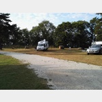
Parkplatz
 The place is a large meadow, which is designated as a parking lot
is usable January - December
[ click for more information ]
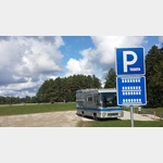
Parkplatz Oru Park
 a nice parking lot at the entrance of Oru Park with avenue view
[ click for more information ]