GIS24.net
Geographic Information System
POI database from MEINWOMOmaps


Geographic Information System
POI database from MEINWOMOmaps
Rastenfeld
/
ADDRESS
 3532 Gemeinde Rastenfeld
Burgsteig
WeiterUrl : https:/ / de.wikipedia.org/ wiki/ Rastenfeld
UrlLoad : https:/ / yes
WikiText : Rastenfeld ist eine Marktgemeinde mit 1.371 Einwohnern im Bezirk Krems-Land in Niederösterreich. Rastenfeld liegt im Waldviertel in Niederösterreich. Die Fläche der Marktgemeinde umfasst 47,55 Quadratkilometer. 51,67 Prozent der Fläche sind bewaldet. Katastralgemeinden sind Marbach im Felde, Mottingeramt, Niedergrünbach, Peygarten-Ottenstein, Rastenberg, Rastenfeld, Sperkental, Zierings.
Click for interactive map
..
Pictures of the Poi and surroundings
Videos about the Poi and the surrounding area
.
.
Things to see in the area
Burg Rastenberg
[ click for more information ]Campingplatz Lichtenfels am Stausee Ottenstein
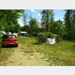 Campsite WITHOUT electricity
is usable May - 16 October
[ click for more information ]
Ruine Lichtenfels
 The ruins, built in the 12th century, are enthroned on a rock high above the Kamp.
 [ click for more information ]
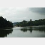
Kamptal Stauseen
[ click for more information ]Schloss Ottenstein
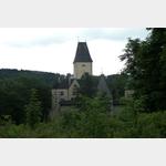 On the northern shore of the reservoir, the castle complex from the 12th century rises high up on a granite rock.
 [ click for more information ]
Golfclub Ottenstein Niedergrunbach 60
[ click for more information ]Schloss Waldreichs
The fortress was first mentioned in a document in 1258 and was converted into a moated castle around 1530.[ click for more information ]