GIS24.net
Geographic Information System
POI database from MEINWOMOmaps


Geographic Information System
POI database from MEINWOMOmaps
Trin
/
ADDRESS

WeiterUrl : https:/ / de.wikipedia.org/ wiki/ Trin
UrlLoad : https:/ / yes
WikiText : Trin, (deutsch und bis 1943 offiziell Trins) ist eine politische Gemeinde im Bezirk Imboden des Kantons Graubünden in der Schweiz. Beschreibung: In Gold (Gelb) über schwarzem Zinnentor vier sechsstrahlige rote Sterne. Grundlage des Wappens war ein Gemeindesiegel, das jedoch vereinfacht übernommen, und in den Farben der Herrschaft Hohentrins und Hewen gestaltet wurde. Die Gemeinde liegt etwa 12 Kilometer westlich der Kantonshauptstadt Chur an der Südseite der Glarner Alpen.
Click for interactive map
..
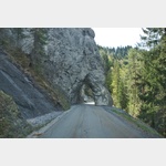
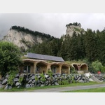
Pictures of the Poi and surroundings
.
Things to see in the area
Camping Trin
 Very quiet place away from the main street of Trin
is usable 1 April - 31 October
[ click for more information ]
ParkenWander
There is a great view of the Rhine Gorge here, but it is very lonely, not for large motorhomes[ click for more information ]
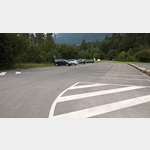
Wanderparkplatz in Trin Mulin
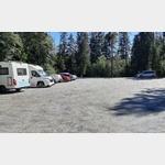 A large level parking lot in Trin Mulin.
 [ click for more information ]
Wasser
Wooden drinking fountain at the roadside[ click for more information ]
Alte Versamer Tobelbrücke
The Versam ravine bridge is half a kilometer north-east of the village center of Versam in the Bündner Surselva in front of the Safiental entrance.[ click for more information ]
Wasser
Wooden water fountain next to the road[ click for more information ]
Wasser
Fountain with drinking water at the roadside[ click for more information ]
Il spir
The 15 m high viewing platform, built in 2006, is at a height of 960 m.[ click for more information ]
Aussichtspunkt Islabord
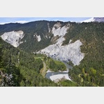 From here you probably have the best view of the Rhine Gorge
[ click for more information ]
Parkplatz Bonaduz
 If the power poles at Bonaduz Square (further west) bother you, you can stay here for a maximum of 12 hours.
 [ click for more information ]
Die Rheinschlucht
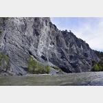 In Graubünden, the Vorderrhein flows through a gorge that is approx.
 [ click for more information ]
Ringelspitzhütte
It is on the southern slope of the Tectonic Arena Sardona and can be reached via Tamins and Vättis.[ click for more information ]