GIS24.net
Geographic Information System
POI database from MEINWOMOmaps


Geographic Information System
POI database from MEINWOMOmaps
Cazis
/
ADDRESS

WeiterUrl : https:/ / de.wikipedia.org/ wiki/ Cazis
UrlLoad : https:/ / yes
WikiText : Cazis (rätoromanisch Cazas bzw. Tgazas) ist eine politische Gemeinde im Kreis Thusis im Bezirk Hinterrrhein im schweizerischen Kanton Graubünden. Auf den 1. Januar 2010 fusionieren die Gemeinden Cazis, Portein, Präz, Sarn und Tartar zur neuen Gemeinde Cazis. Die Gemeinde liegt rund drei Kilometer nordöstlich von Thusis und besteht aus den 7 Fraktionen (Ortsteilen) Luvreu, Oberrealta, Ratitsch, Schauenberg, Summaprada, Unterrealta und Valleina. Vom gesamten Gemeindegebiet von 727 ha sind 299 ha von Wald und Gehölz bedeckt, 298 ha sind landwirtschaftliches Nutzgebiet, 99 ha Siedlungsfläche und die restlichen 31 ha unproduktive Fläche (meist Gebirge).
Click for interactive map
..
Pictures of the Poi and surroundings
.
Things to see in the area
Raiffeisen Sarn (Heinzenberg)
[ click for more information ]Raiffeisen Mittelbünden
[ click for more information ]Heinzenberg-Lescha
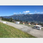
A parking space at an altitude of approxopen 5 May - 31 October
[ click for more information ]
Parkplatz am Skilift
In the parking lot for the ski lift, in summer there is plenty of space to stand with a great viewopen January - December
[ click for more information ]
Cazis
[ click for more information ]Lidl Thusis
[ click for more information ]Aldi
[ click for more information ]Spital Thusis
Phone: 41 (0)81 632 11 11[ click for more information ]
sonstiges
Follow the signs to the ´Thusis petrol station´, within the large parking area an area for mobile homes is marked.[ click for more information ]
Bahnhof Thusis
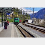 Rhaetian Railway station in Thusis.
 [ click for more information ]
Parkplatz beim Waldschwimmbad
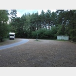 Quiet place in the forest.
 [ click for more information ]
Parkplatz Skilift Oberurmein
 Quiet parking lot in the place of the ski lift.
 [ click for more information ]