GIS24.net
Geographic Information System
POI database from MEINWOMOmaps
Ý


Geographic Information System
POI database from MEINWOMOmaps
Ý
Kalavrita
/
ADDRESS
 25001 Δήμος Καλαβρύτων, κ. Καλαβρύτων
EO31
WeiterUrl : https:/ / de.wikipedia.org/ wiki/ Kalavrita
UrlLoad : https:/ / yes
WikiText : Kalavryta, auch Kalavrita (griechisch ,ŒŒŒŒŒœœœŒ (n. ,pl.)) ist ein Dorf mit ca. 2000 Einwohnern in der Pr‰fektur Achaia im Norden der Peloponnes und erlangte aufgrund eines Massakers vom 13. Dezember 1943 Bekanntheit. Der Ort liegt im fruchtbaren Hochtal des zum Golf von Korinth entw‰ssernden Flusses Vouraikos am s¸dlichen Hang in ca. 740 m Hˆhe, westlich flankiert vom Gebirgsmassiv des Erymanthos, 2221 m. ñstlich dominiert, in groþer N‰he, das Gebirgsmassiv des Aroania, 2338 m. In dieser Gebirgslandschaft kommt es zwischen Dezember und April zu reichlichen Niederschl‰gen. Der Fluss f¸hrt daher das ganze Jahr ¸ber Wasser, obwohl diese Landschaft, wie fast der ganze Peloponnes, durch Karstph‰nomene und sehr regenarme Sommer gepr‰gt ist.
Click for interactive map
..
Pictures of the Poi and surroundings
.
Things to see in the area
[ click for more information ]
Bahnhof Kalavryta
Bahnhof Kalavryta.[ click for more information ]
Furnished apts Esperides
[ click for more information ]Traditional hotel Chelmos
[ click for more information ]Hotel Filoxenia
[ click for more information ]Hotel Maria
[ click for more information ]Hotel ΚΥΝΑΙΤΗΑ
[ click for more information ]Parkplatz, auch zum Ðbernachten
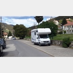 Parking lot directly below the station of the funicular
is usable March - November
[ click for more information ]
jet
2144498_Beschreibung[ click for more information ]
PirgotÛ
λ[ click for more information ]