GIS24.net
Geographic Information System
POI database from MEINWOMOmaps


Geographic Information System
POI database from MEINWOMOmaps
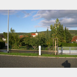
Fladungen
/
ADDRESS
97650 FladungenLudwigstraße
WeiterUrl : https:/ / de.wikipedia.org/ wiki/ Fladungen
UrlLoad : https:/ / yes
WikiText : 2.217 (31. ,Dez. ,2008)[1] Fladungen ist eine Stadt im unterfränkischen Landkreis Rhön-Grabfeld und Sitz der Verwaltungsgemeinschaft Fladungen. Der staatlich anerkannte Erholungsort ist die nördlichste Stadt Bayerns. Fladungen ist die nördlichste Stadt in Unterfranken. Fladungen liegt in der Region Main-Rhön, im Tal der Streu.
Click for interactive map
..
Pictures of the Poi and surroundings
.
Things to see in the area
Rundweg Museumstour
Die Museumstour in Fladungen erstreckt sich über 20 km.[ click for more information ]
Christuskirche
Evangelisch-Lutherische Kirchengemeinde Fladungen[ click for more information ]
Fränkisches Freilandmuseum Fladungen
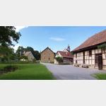 The museum for village culture in Lower Franconia! You can expect: farmhouses, a brewery, two mills, the village church and school.
 [ click for more information ]
TouristInfo
Tourist Information Fladungen - Rhön[ click for more information ]
Campingplatz Fladungen
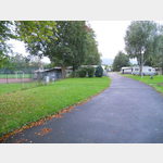 3 parking spaces within the predominantly occupied by permanent campers campsite
is open January - December
[ click for more information ]
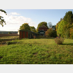
Wellness Bauernhof Weihersmühle
Camping at the farmer´s, a bit away from the villageis usable 1 January - 31 December
[ click for more information ]
Dorfkirche
Evangelische Kirche[ click for more information ]
Dreifaltigkeitskirche
Evangelisch-Lutherische Kirchengemeinde[ click for more information ]
Hildenburg
The ruins of Hildenburg probably date back to the 8th century.[ click for more information ]
Grünes Band Thüringen - Etappe 8
The Green Belt, the former border between FRG and GDR Stage 8 from Weimarschmieden to Wassermannshof The last stage of the Rennsteig takes you through the dense forests of the Thuringian Slate Mountains up to the banks of the still young Saale.[ click for more information ]
Rother Kuppe
The 21 m high tower is the third on the 710 m high Rother Kuppe.[ click for more information ]
Rother Kuppe
Built as a hostel in 1960, the restaurant is open all year round.[ click for more information ]