GIS24.net
Geographic Information System
POI database from MEINWOMOmaps


Geographic Information System
POI database from MEINWOMOmaps
Umhausen
/
ADDRESS
 6441 Umhausen
Köfels
WeiterUrl : https:/ / de.wikipedia.org/ wiki/ Umhausen
UrlLoad : https:/ / yes
WikiText : Umhausen ist eine Gemeinde im Bezirk Imst, Tirol, sterreich. Sie liegt im tztal in einer Talweitung auf dem Murkegel des Horlachbachs, verstreut auf verschiedene Weiler und Dörfer. Ortsteile: Umhausen, Tumpen, Köfels, Farst, Niederthai, sten Umhausen war ein Zentrum des Flachsanbaus. Heute ist die Gemeinde ein zweisaisonaler Fremdenverkehrsort, ohne jedoch auf den Massentourismus zu setzen. Zusätzlich gibt es einige Gewerbebetriebe.
Click for interactive map
..
Pictures of the Poi and surroundings
Videos about the Poi and the surrounding area
.


.
Things to see in the area
Wenderkogl 2200 m
[ click for more information ]Bucht
Kneipp facilities in Umhausen[ click for more information ]
Tageswanderparkplatz
 Update 2018, see Bikder, only allowed during the day Parking lot by the natural outdoor pool and Ötzidorf Nice and quiet in the evening.
 [ click for more information ]
P Badesee Umhausen
[ click for more information ]Spielplatz
[ click for more information ]Bucht
Umhausen natural bathing lake[ click for more information ]
Camping Ötztal Umhausen
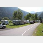 Open all year round
 is open January - December
[ click for more information ]
Baecker
Baker, Dorf 17, A 6441 Umhausen[ click for more information ]
Friedhof
Freidhof Umhausen[ click for more information ]
Aqua Dome
Very nice thermal baths with a large sauna area.[ click for more information ]
Parkgarage Aqua Dome
not for tall campers[ click for more information ]