GIS24.net
Geographic Information System
POI database from MEINWOMOmaps


Geographic Information System
POI database from MEINWOMOmaps
Zufikon
/
ADDRESS

WeiterUrl : https:/ / de.wikipedia.org/ wiki/ Zufikon
UrlLoad : https:/ / yes
WikiText : Zufikon (schweizerdeutsch: Zfike) ist eine Einwohnergemeinde im Bezirk Bremgarten im Schweizer Kanton Aargau. Das Dorf liegt unmittelbar östlich des Bezirkshauptorts Bremgarten. Das historische Dorfzentrum besteht aus dem Oberdorf und dem etwa 300 Meter entfernten Unterdorf. Beide liegen auf einer Höhe von rund 405 Metern am Rande der flachen Ebene östlich der Reuss. Der Südwesthang des Mutschellen wurde in den letzten Jahrzehnten praktisch lückenlos mit Einfamilienhäusern überbaut. Aus diesem Grund ist Zufikon nicht nur mit Bremgarten zusammengewachsen, sondern auch mit Widen und Berikon. Die Fläche des Gemeindegebiets beträgt 480 Hektaren, davon sind 130 Hektaren mit Wald bedeckt und 99 Hektaren überbaut. Der höchste Punkt befindet sich auf einer Höhe von 542 Metern, die tiefste Stelle liegt auf 373 Metern an der Reuss.
Click for interactive map
..
Pictures of the Poi and surroundings
Videos about the Poi and the surrounding area
.


.
Things to see in the area
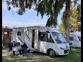
Parkplatz
A quiet parking lot by the swimming pool and the riveropen -
[ click for more information ]
Mutschellenpass
Der Mutschellen ist ein Pass auf 551m im Bezirk Bremgarten des Kantons Aargau nahe der Grenze zum Kanton Zürich.[ click for more information ]
Flachsee
Der Flachsee ist der rund 1,4 Kilometer lange südliche Teil des Stausees an der Reuss im Kanton Aargau[ click for more information ]
Parkplatz Hauptstraße 2
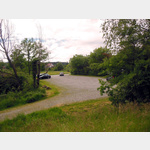 Generous, quiet hiking car park in a rural setting.
 [ click for more information ]
Stille Reuss
Der See liegt auf einer Höhe von 378 Metern über Meer und ist heute ganz vom Fluss Reuss abgetrennt.[ click for more information ]
Erdmannlistein
Here is the Erdmannlistein, a stone formation from the Würm Ice Age.[ click for more information ]
Ortsmuseum Bellikon
The local museum Bellikon documents the local history[ click for more information ]
Volg
with postal agency[ click for more information ]
Schnepfenweiher
Er liegt südwestlich des Dorfkerns auf einer Höhe von 559m[ click for more information ]
Parkplatz für Wohnmobile und PKWs
Large parking lot, relatively quiet location[ click for more information ]
Fischbacher Moos
Er liegt auf einer Höhe von 400m südlich von Fischbach-Göslikon.[ click for more information ]
Ortsmuseum Bergdietikon
The Bergdietikon local museum is located in the community center and shows the needs of the community during World War II.[ click for more information ]
Volg
with postal agency[ click for more information ]