GIS24.net
Geographic Information System
POI database from MEINWOMOmaps


Geographic Information System
POI database from MEINWOMOmaps
Ebnat-Kappel
/
ADDRESS

WeiterUrl : https:/ / de.wikipedia.org/ wiki/ Ebnat-Kappel
UrlLoad : https:/ / yes
WikiText : Ebnat-Kappel ist eine politische Gemeinde im Kanton St. Gallen in der Schweiz. Die Gemeinde Ebnat-Kappel befindet sich im Wahlkreis Toggenburg. Zu ihr gehören die Weiler Brandholz, Wintersberg und Bendel. Der höchste Berg Ebnat-Kappels und zugleich der höchste Nagelfluhberg Europas ist der Speer mit 1950 m. ü. M. Oberhalb vom Dorf auf ungefähr 800 m. ü. M. liegt der Skilift Tanzboden. Dank Scheinwerfern ist dort auch Nachtskifahren möglich. Nicht mehr in Betrieb ist das Skigebiet Girlen, an dessen Hängen in den 1970er-Jahren legendäre Rennen des Ski-Weltcups stattfanden (zu den Resultaten).
Click for interactive map
..
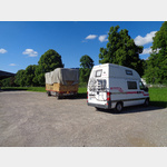
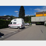
Pictures of the Poi and surroundings
Videos about the Poi and the surrounding area
.
.
Things to see in the area
Turngeräte-Museum
The exhibition shows 300 years of history of gymnastics.[ click for more information ]
Bahnhof EbnatKappel
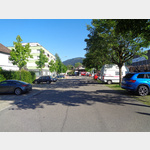 Parking spaces on both sides of the railway tracks.
 [ click for more information ]
Gill-Apotheke
[ click for more information ]Ackerhus
The Ackerhus Museum in a Toggenburg house from the 18th century shows collections of Toggenburg domestic culture from four centuries.[ click for more information ]
Eichweiher
Der Eichweiher liegt in der Toggenburger Gemeinde Ebnat-Kappel im Kanton St.[ click for more information ]
Raiffeisen Ebnat-Kappel
[ click for more information ]Bäckerei Schambron
[ click for more information ]Markthalle Toggenburg
 Switzerland´s largest cattle and calf market takes place every Monday.
 [ click for more information ]
Packgeiss
1/2 day to 2 day tours, with and without overnight stays.[ click for more information ]
Parkplatz Tiefgarage Wattwil
 The car park is opposite the train station in the underground car park.
 [ click for more information ]