GIS24.net
Geographic Information System
POI database from MEINWOMOmaps


Geographic Information System
POI database from MEINWOMOmaps
Bonaduz
/
ADDRESS

WeiterUrl : https:/ / de.wikipedia.org/ wiki/ Bonaduz
UrlLoad : https:/ / yes
WikiText : Bonaduz (rätoromanisch Panaduz) ist eine politische Gemeinde im Kreis Rhäzüns im Bezirk Imboden des Kantons Graubünden in der Schweiz. Beschreibung: In Silber (Weiss) eine blaue Deichsel überhöht von einem sechsstrahligen roten Stern. Die Deichsel verweist einerseits auf die Vereinigung von Vorder- und Hinterrhein in der Nähe der Gemeinde hin, sie kann aber auch auf die Gabelung der Verkehrsströme zu den verschiedenen Alpenpässen hinweisen. Der Stern verweist auf das Patrozinium der Pfarrkirche: die heilige Anna oder Maria. Die Gemeinde liegt auf einem Plateau oberhalb des Zusammenflusses von Vorderrhein (am Ausgang der Rheinschlucht) und Hinterrhein. Welche durch eine gewaltige Naturkatastrophe, den Flimser Bergsturz entstanden ist. Die Ortschaft Bonaduz liegt in der Talebene auf 662 ,m, die Tiefebene auf rund 590 ,m und das Bergland auf ca. 1500 ,m (Alp Sut).
Click for interactive map
..
Pictures of the Poi and surroundings
.
Things to see in the area
Coop
[ click for more information ]Raiffeisen Bonaduz
[ click for more information ]Rhein
The Rhine is formed here by the confluence of the Vorderrhein and Hinterrhein.[ click for more information ]
ParkenAll
[ click for more information ]Parkplatz Bonaduz
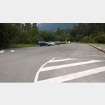 If the power poles at Bonaduz Square (further west) bother you, you can stay here for a maximum of 12 hours.
 [ click for more information ]
Raiffeisen Tamins
[ click for more information ]Parkenwomo
[ click for more information ]Bahnhof Reichenau-Tamins
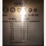 Parking Bahnhof Reichenau-Tamins, per machine, only coins possible!Toilette And restaurant at the station
open January - December
[ click for more information ]
Parkenpkw
[ click for more information ]Wohnmobilstellplatz Bonaduz
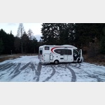 Parking space marked with a WomoSignet, overnight stay allowed
is open January - December
[ click for more information ]
Golfclub Domat Ems
3 x 9-hole course at almost 600m above sea level.[ click for more information ]
Ringelspitzhütte
It is on the southern slope of the Tectonic Arena Sardona and can be reached via Tamins and Vättis.[ click for more information ]