GIS24.net
Geographic Information System
POI database from MEINWOMOmaps


Geographic Information System
POI database from MEINWOMOmaps
Højer
/
ADDRESS
 Højer
HøjerSlusevej
WeiterUrl : https:/ / de.wikipedia.org/ wiki/ Højer
UrlLoad : https:/ / yes
WikiText : Vorlage:Infobox Ort in Dänemark/Wartung/Einwohnerzahl fehltVorlage:Infobox Ort in Dänemark/Wartung/Fläche fehltVorlage:Infobox Ort in Dänemark/Wartung/Höhe fehlt Hjer [hiÌ] (deutsch: Hoyer, friesisch: Huuger) ist eine Ortschaft in der Tnder Kommune in Dänemark. Sie liegt unmittelbar an der Nordsee und an der deutsch-dänischen Grenze. Im Flecken wohnen 1.700 Einwohner, weitere 400 im Landkirchspiel. Das Landkirchspiel umfasst 29 ,km, der Flecken Hoyer 9,5 ,km. Die Kirchspiele Emmerleff und Dahler sind auch die nördlichen Nachbarn von Flecken und Landgemeinde Hoyer. Im Osten liegt Mögeltondern und im Süden grenzt Hoyer an die Gemeinden Aventoft und Rodenäs.
Click for interactive map
..
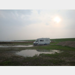
Pictures of the Poi and surroundings
.
Things to see in the area
Wohnmobilstellplatz Hohenwarte
A parking space at a hotel not far from the seais usable 1 January - 31 December
[ click for more information ]
Bådfolk ved Vidåen
[ click for more information ]Højer Havn
[ click for more information ]Mühle von Højer
[ click for more information ]Keramiker Jytte Lysgard
[ click for more information ]Petrikirche
[ click for more information ]Restaurant Slusen Hoyer
Parking at the lock and at a restaurantusable January - December
[ click for more information ]
Emmerlev Kirke
[ click for more information ]Parkenwander
[ click for more information ]UNESCO Weltkulturerbe - Wattenmeer Deutschland 2
The Wadden Sea of the North Sea from Den Helder in the Netherlands to Skallingen in Denmark is around 9000 km² in size and 450 km long, making it the largest Wadden Sea in the world.[ click for more information ]