GIS24.net
Geographic Information System
POI database from MEINWOMOmaps


Geographic Information System
POI database from MEINWOMOmaps
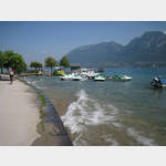
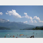
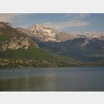
Saint-Jorioz
/
ADDRESS
74410 Saint-JoriozRoute du Port
WeiterUrl : https:/ / de.wikipedia.org/ wiki/ Saint-Jorioz
UrlLoad : https:/ / yes
WikiText : Saint-Jorioz ist eine Gemeinde im französischen Dpartement Haute-Savoie in der Region Rhne-Alpes. Saint-Jorioz liegt auf 465 m ü. M., etwa 8 km südsüdöstlich der Stadt Annecy (Luftlinie). Das Dorf erstreckt sich westlich des Lac dAnnecy auf einer Schwemmebene am Bach Laudon, am Ostfuß des zum Massiv der Bauges gehörenden Semnoz. Die Fläche des 21.12 km großen Gemeindegebiets umfasst einen Abschnitt am Westufer des Lac dAnnecy. Das Hauptsiedlungsgebiet wird von der rund 2 km breiten und 4 km langen Schwemmebene eingenommen, die der Laudon und einige Seitenbäche im Lauf der Zeit an der Mündung in den Lac dAnnecy aufgeschüttet haben. Nach Süden erstreckt sich das Gemeindeareal in die breite Senke des Pays du Laudon. Sie wird im Osten vom schroffen Felsgrat des Roc des Bufs (bis 1200 m ü. M.) und im Westen vom Höhenrücken des Semnoz begrenzt. Der Hang und der Kammbereich des Semnoz sind dicht bewaldet, und unterhalb des Gipfels des Crt du Chtillon wird mit 1652 m ü. M. die höchste Erhebung von Saint-Jorioz erreicht.
Click for interactive map
..
Pictures of the Poi and surroundings
.
Things to see in the area
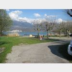
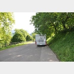
Parkplatz
A large parking lot not far from the centeropen -
[ click for more information ]
Cimetiere du Centre
[ click for more information ]Cimetiere du Centre
[ click for more information ]Tennis Club St.Jorioz
[ click for more information ]Cimetiere de la Tire
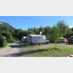
[ click for more information ]Camping Le Solitaire du Lac
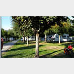 Accepts ACSI Card
 usable 7 April - 10 October
[ click for more information ]
Camping International du Lac d Annecy
Accepted ACSI Cardopen 26 April - 20 September
[ click for more information ]
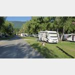
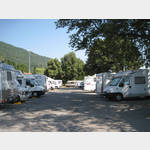
Camping Univers
The campsite is just a few meters from Lac d´Annecyusable 15 June - 30 September
[ click for more information ]
Camping Europa Lake d Annecy
 The course is approx
is usable 1 April - 12 September
[ click for more information ]
Camping Les Rives du Lac
 Accepts ACSI Card
 is usable 27 March - 30 September
[ click for more information ]
Camping Le Familial
 Accepts ACSI Card
 usable 26 March - 30 September
[ click for more information ]
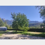
Camping Le Crêtoux
The campsite is located at an altitude of 580 m above sea level overlooking Lake Annecyusable 4 May - 26 October
[ click for more information ]
Camping Le Panoramic
Accepted ACSI Cardis open 18 April - 30 September
[ click for more information ]
Aire de Duingt
Camper service in front of the campsite, gray water disposal is only possible with a bucket or hoseis open 1 January - 31 December
[ click for more information ]
Camping Municipal Les Champs Fleuris
A nice place close to the lakeis usable 7 April - 1 October
[ click for more information ]
Parkplatz Route du Port
 Junction N508 towards Faverges and Port de Sevrier How to get there: Parking right on the D 1508.
 [ click for more information ]
ParkenAll
PP of the Eco Museum.[ click for more information ]
Golf du Lac d´Annecy
Golf du Lac d´Annecy Talloires Chemin Rural de Sablons aux Reposoir[ click for more information ]
Mairie
Mairie Menthon-Saint-Bernard[ click for more information ]
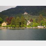
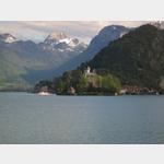
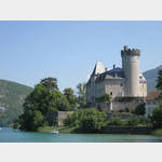
Chateau de Duingt
Castle Chateau de Duingt[ click for more information ]
Menton Saint Bernard
 Parking to visit the Menton Saint Bernard Castle.
[ click for more information ]