GIS24.net
Geographic Information System
POI database from MEINWOMOmaps


Geographic Information System
POI database from MEINWOMOmaps
Olvera
/
ADDRESS
OlveraCalle Llana
WeiterUrl : https:/ / de.wikipedia.org/ wiki/ Olvera
UrlLoad : https:/ / yes
WikiText : Auf der höchsten Erhebung mitten im Ort befinden sich eine Pfarrkirche, die auf den Resten einer maurischen Moschee errichtet wurde und eine Burgruine. Beide sind ausschließlich von niedrigen weißen Häuserreihen umgeben, die den Charakter des Dorfes ausmachen. Das Landschaftsbild um Olvera ist von Landwirtschaft geprägt, hauptsächlich durch Oliven-Haine und Kornfelder. Zu Zeiten des Mittelalters war Olvera eine Station auf der Schmugglerstraße von Ronda nach Morn de la Frontera.
Click for interactive map
..
Pictures of the Poi and surroundings
.
Things to see in the area
CASTILLO ÀRABE DE OLVERA
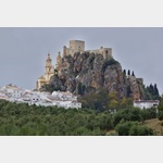 The Castillo Olvera is a small castle of Arabic origins, picturesquely perched on a 100 m high cliff above Olvera.
[ click for more information ]
Kirche Parroquia Nuestra Senora de la Encarnacion
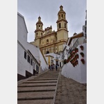 The Parroquia Nuestra Senora de la Encarnacion church is one of the symbols of Olvera, together with the old Arab castle.
 [ click for more information ]
Parkenpkw
[ click for more information ]Parkenpkw
[ click for more information ]ParkenAll
[ click for more information ]Iglesia del Socorro
[ click for more information ]ParkenAll
[ click for more information ]Iglesia de San Jose de la Montana
[ click for more information ]Parkenwomo
[ click for more information ]Wohnmobilstellplatz Alter Bahnhof Via verde
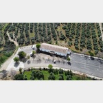 A parking space up to 3
is open 1 January - 31 December
[ click for more information ]
Von Olvera nach Puerto Serrano
This Via Verde is one of the most impressive cycle routes on old railway lines in Spain.[ click for more information ]