GIS24.net
Geographic Information System
POI database from MEINWOMOmaps


Geographic Information System
POI database from MEINWOMOmaps
Verbandsgemeinde Rheinböllen
/
ADDRESS
55494 RheinböllenB 50
WeiterUrl : https:/ / de.wikipedia.org/ wiki/ Verbandsgemeinde Rheinböllen
UrlLoad : https:/ / yes
WikiText : Verbandsgemeinden sind Gebietskörperschaften eines deutschen Bundeslandes. Es handelt sich dabei um eine Art Verwaltungsgemeinschaft mehrerer selbstständiger Gemeinden, die zur Erledigung ihrer Verwaltungsgeschäfte eine neue Gebietskörperschaft, die Verbandsgemeinde, bilden. Verbandsgemeinden gibt es seit 1969/1970 in Rheinland-Pfalz, siehe: Verbandsgemeinde (Rheinland-Pfalz). Seit 1. Juli 2009 auch in Sachsen-Anhalt, siehe Verbandsgemeinde (Sachsen-Anhalt)
Click for interactive map
..
Pictures of the Poi and surroundings
.
Things to see in the area
Bäcker
[ click for more information ]Einkaufsparkplatz
[ click for more information ]Metzger
[ click for more information ]Netto Marken-Discount
[ click for more information ]Bäcker
[ click for more information ]Apotheke
[ click for more information ]Aussichtsturm Hochsteinchen
The 18 m high tower, built in 1894, stands on the 648 m high Hochsteinchen.[ click for more information ]
RV park Ellern
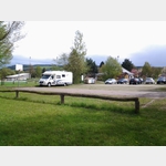 Parking at the sports ground with panoramic view in the Hunsrück
open 1 January - 31 December
[ click for more information ]
Parkplatz Autobahn
Struth A 61 Liebshausen car park[ click for more information ]
Parkplatz Autobahn
Hundsheide A 61 Liebshausen car park[ click for more information ]
Hochsteinchen-Tour
The Hochsteinchentour leads along forest paths along spruce and mixed forests, offering wide views over the Hunsrück and up to the peaks of the Eifel.[ click for more information ]