GIS24.net
Geographic Information System
POI database from MEINWOMOmaps


Geographic Information System
POI database from MEINWOMOmaps
Carrickfergus
/
ADDRESS
 County Antrim
Albert Road
WeiterUrl : https:/ / de.wikipedia.org/ wiki/ Carrickfergus
UrlLoad : https:/ / yes
WikiText : Carrickfergus liegt in Antrim elf Kilometer nordöstlich der Hauptstadt Belfast in Südlage am Meer. Bekannt ist er durch die Schlacht von Carrickfergus im Neunjährigen Krieg und durch das Carrickfergus Castle, eine normannische Burg auf einem schwarzen Basaltfelsen, die 1180 durch John de Courcy erbaut wurde. Carrickfergus hat einen Jachthafen und das Andrew Jackson Centre, das an den US-amerikanischen Präsidenten Andrew Jackson erinnert, dessen Eltern Carrickfergus als Auswanderer verließen. Das irische Volkslied Carrickfergus, bei dem es um Heimweh nach der Stadt geht, ist eine bersetzung aus dem Irischen, und kommt aus Munster. Es wurde von zahlreichen Musikern interpretiert, darunter Bryan Ferry, Joan Baez, The Dubliners, Declan Galbraith, The Chieftains, Van Morrison, Subway to Sally (in deutscher bersetzung), Celtic Woman und Loreena McKennitt.
Click for interactive map
..
Pictures of the Poi and surroundings
.
Things to see in the area
Harbour Car Park
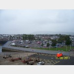 The car park is at Carrickfergus harbor near the Norman Castle
open 1 January - 31 December
[ click for more information ]
Sainsbury
[ click for more information ]Einkaufsmöglichkeit
[ click for more information ]Tesco Extra
[ click for more information ]Einkaufsmöglichkeit
[ click for more information ]Carrickfergus Harbour in Northern Ireland
[ click for more information ]Supermarkt-Tankstelle
[ click for more information ]McDonald
[ click for more information ]Maritime Drive
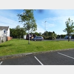 The parking space in front of the castle was occupied by fairground
usable 1 January - 31 December
[ click for more information ]