GIS24.net
Geographic Information System
POI database from MEINWOMOmaps


Geographic Information System
POI database from MEINWOMOmaps
Altenburg
/
ADDRESS
04600 Altenburg, KosmaWeiterUrl : https:/ / de.wikipedia.org/ wiki/ Altenburg
UrlLoad : https:/ / yes
WikiText : Die ehemalige Residenzstadt Altenburg ist über 1000 Jahre alt, liegt im Osten des Freistaates Thüringen und gehört zur Metropolregion Sachsendreieck. Altenburg ist Kreisstadt des Landkreises Altenburger Land. Mit ihren etwa 37.000 Einwohnern ist die Stadt in der Landesplanung als Mittelzentrum mit Teilfunktionen eines Oberzentrums ausgewiesen. Sie wurde vor allem durch das hier um 1820 erfundene Kartenspiel Skat bekannt. Altenburg befindet sich fast in der Mitte des Städtedreiecks Leipzig-Chemnitz-Gera. Die Stadt liegt 28 ,km nordöstlich von Gera, 39 ,km südlich von Leipzig, 38 ,km nordwestlich von Chemnitz und 31 km nördlich von Zwickau. Sie wurde auf einem hügligen Gebiet erbaut, dessen tiefster Punkt bei Zschernitzsch mit 162 ,m und der höchste bei Mockzig mit 261 ,m ü. NN. liegt. Das Gebiet gehört zu den letzten Ausläufern des Erzgebirgsvorlandes, die nördlich der Stadt in der Leipziger Tieflandsbucht enden. Altenburg wird von den Gewässern Pleiße, Blaue Flut und Deutscher Bach durchflossen. Der Fluss Pleiße durchfließt die Stadt im Süden im Ortsteil Ehrenberg. Das Gewässer Deutscher Bach fließt im Norden Altenburgs durch die Stadtteile Steinwitz, Drescha, Nord und Kauerndorf, wo der Bach dann in die Blaue Flut mündet. Diese wiederum entspringt bei Graicha im Altenburger Land und durchfließt die Stadt von Süd-West nach Nord-Ost. Sie wurde nach einer hier ansässigen Färberei benannt, die das meist blaue Färbereiabwasser ungeklärt in den Bach abließ.
Click for interactive map
..
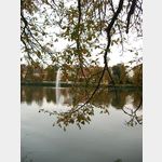
Pictures of the Poi and surroundings
Videos about the Poi and the surrounding area
.
.
Things to see in the area
Rathaus
The Altenburg Town Hall dates back to the mid-16th century.[ click for more information ]
Altenburger Hauptmarkt
 The Altenburg main market, with the town hall, the Brüderkirche and the long rows of shops, is the center of the old town.
[ click for more information ]
Brüderkirche
The neo-Gothic church was built between 19023 and 1905.[ click for more information ]
Nikolaikirchturm
In the 13th century the church from the 11th century was renovated.[ click for more information ]
Skatbrunnen
The Skat Fountain is dedicated to the card game that was invented in Altenburg, Skat.[ click for more information ]
Historischer Frisörsalon
Artur Grosse´s hairdressing salon from 1926 to 1966 in original condition.[ click for more information ]
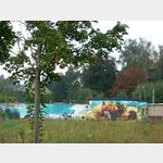
Wohnmobilstellplatz am Großen Teich
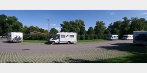 The square is close to the old town on the access road to the outdoor pool
is usable January - December
[ click for more information ]
Teehaus
The teahouse was built as a baroque pleasure house between 1706 and 1712 according to plans by the master builder Johann Heinrich Gengenbach.[ click for more information ]
Herzog-Agnes-Gedächtniskirche
Heinrich Ernst I of Saxony donated the church in memory of Duchess Agnes, who died in 1897.[ click for more information ]
Mauritianum
The museum was built from 1907 to 1908 on behalf of the reigning Duke Ernst I.[ click for more information ]
Wettiner Straße
Wettiner Strasse stretches from the train station to the Lindenau Museum and is lined with villas of various designs and in very different states of preservation.[ click for more information ]
Bismarckturm Altenburg
In 1915 the tower was opened.[ click for more information ]
Schloss Poschwitz
Poschwitz Castle First mention in 1246.[ click for more information ]
Schloss Ehrenberg
Ehrenberg Palace First documented mention in 1244.[ click for more information ]