GIS24.net
Geographic Information System
POI database from MEINWOMOmaps


Geographic Information System
POI database from MEINWOMOmaps
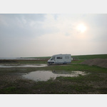
Insel Sylt im Wattenmeer
Sight /
The island of Sylt in the northern Frisian Wadden Sea is 38 km long, has around 15,000 inhabitants and is almost 100 m2 in size. It is connected to the mainland by a dam and the northern tip is the northernmost point in Germany. The island is world famous for its long beaches and mud flats on the eastern side. This route/eBook contains the parking spaces and campsites on the island as well as the most important sights with shopping tips and selected restaurants and bars as well as many film tips.
ADDRESS
25924 KlanxbüllClick for interactive map
..
Pictures of the Poi and surroundings
Videos about the Poi and the surrounding area
.
Routes and books with this POI
UNESCO Weltkulturerbe - Wattenmeer Deutschland 2
Alle Routen zu Topzielen 2020
Things to see in the area
Wanderparkplatz Rhynschlotbrücke
[ click for more information ]Parkenwander
[ click for more information ]Insel Sylt im Wattenmeer
The island of Sylt in the northern Frisian Wadden Sea is 38 km long, has around 15,000 inhabitants and is almost 100 m2 in size.[ click for more information ]
Hindenburgdamm
In June 1927, after 4 years of construction, the 11 km long Hindenburgdamm was opened.[ click for more information ]
UNESCO Weltkulturerbe - Wattenmeer Deutschland 2
The Wadden Sea of the North Sea from Den Helder in the Netherlands to Skallingen in Denmark is around 9000 km² in size and 450 km long, making it the largest Wadden Sea in the world.[ click for more information ]