GIS24.net
Geographic Information System
POI database from MEINWOMOmaps


Geographic Information System
POI database from MEINWOMOmaps
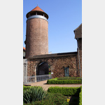
Burg Wendelstein
Sight / Castle
Wendelstein Castle
First mentioned in 1294
This castle complex was founded and militarily equipped under Abbot Heinrich IV of Fulda.
Today substantially preserved, freely accessible and used as a museum.
ADDRESS
36404 Vacha
Untertor
Click for interactive map
..
Pictures of the Poi and surroundings
Videos about the Poi and the surrounding area
.
Routes and books with this POI
Deutschland Alleenstraße 4. Abschnitt
.
Things to see in the area
Burg Wendelstein
[ click for more information ]Brücke der Einheit
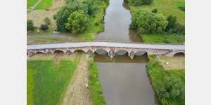 The 225 m long stone arch bridge was built in the Middle Ages and divided into 2 parts in 1961.
 [ click for more information ]
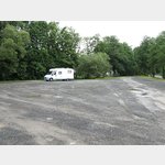
Wohnmobilstellplatz Vacha
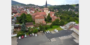 Free parking space is available in Vacha, Thuringia, Germany, January - December Service: Garbage Water Disposal Electricity. Parking space in a larger parking lot directly at the entrance to the city center on the B62 opposite the Werra Bridge
[ click for more information ]
Rathaus in Vacha
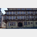 Historical town hall in Vacha The town hall is the dominant focal point of the medieval market and was built in 1613.
 [ click for more information ]
Ökumenischer Pilgerweg
[ click for more information ]PENNY
[ click for more information ]Einkaufsparkplatz
[ click for more information ]Vitus-Apotheke
[ click for more information ]Parkplatz am Schwimmbad
 Free parking space can be used in Vacha, Thuringia, Germany January - December Simple parking space next to the swimming pool on the outskirts of Vacha, approx
[ click for more information ]
Grünes Band Thüringen - Etappe 10
Das Grüne Band, die ehemalige Grenze zwischen BRD und DDR Etappe 10 von Philippsthal nach Herleshausen Geschichte und Gegenwart, Natur und Kultur treffen am Grünen Band aufeinander.[ click for more information ]
Keltenpfad Rhön
A 17 km long hiking trail over the Rhön[ click for more information ]
Ulster Mündung
The Ulster, source in the High Rhön between the Ottilienstein and Heidelstein mountains, flows into the Werra after 57 km.[ click for more information ]