GIS24.net
Geographic Information System
POI database from MEINWOMOmaps


Geographic Information System
POI database from MEINWOMOmaps
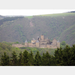
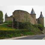
Château du Bourscheid
Sight / Castle
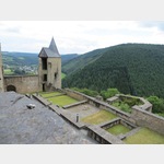
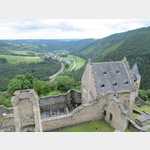
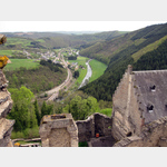
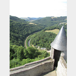
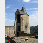
The ruins of the once imposing castle stand on a 150 m high rock on the right bank of the Sauer. The 12,000 m² area was surrounded by a wall with kennels and 11 towers.
1095 the then wooden fortress was first mentioned and the first expansion started. The large ring wall and the lower castle were added around 1350. The last reinforcement, the moat and the gate bastion, in 1477 made the castle almost impregnable.
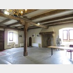
With the death of the last Bourscheider in 1512, the castle fell into disrepair and it was only in 1972, when the state acquired the fortress, that restoration work began.
The magnificent view of the Sauer valley and the interesting audio guide make Bourscheid a worthwhile excursion destination.
26.10.2014: Medieval, z. T. renewed castle ruins at Bourscheid (Luxembourg).. German-speaking guide by ´mobile´.
ADDRESS
 9140 Bourscheid
Rue de Château
Ausstattung : Besichtigung möglich
Click for interactive map
..
Pictures of the Poi and surroundings
Routes and books with this POI
Mit dem WOMO durch Luxemburg und Belgien
.
Things to see in the area
Château du Bourscheid
[ click for more information ]Camping Um-Gritt Castlegarden
Accepted ACSI Card (red), ADAC Camp Cardis open 28 March - 31 October
[ click for more information ]
Camping Du Moulin
A nice campsite on the riveris open 29 April - 30 September
[ click for more information ]