GIS24.net
Geographic Information System
POI database from MEINWOMOmaps


Geographic Information System
POI database from MEINWOMOmaps
Picture /
ADDRESS
 3860 Schattenhalb
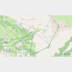
Click for interactive map
..
Pictures of the Poi and surroundings
.
Things to see in the area
Campingplatz Aareschlucht
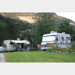 Small, family-run campsite, ideally situated for visiting the Aare Gorge
is open May - October
[ click for more information ]
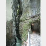
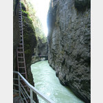
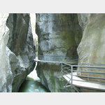
Aareschlucht
West entrance of the Aare Gorge.[ click for more information ]
Camping Grimselblick
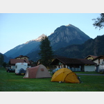 Small campsite in a rural setting, good starting point for the Alpine passes
open 1 January - 31 December
[ click for more information ]
Supermarkt Volg
Mon-Fri 07:00-18:30«, » Sat, Su, PH 07:00-16:00[ click for more information ]
Camping Grund
Accepts ACSI Cardopen 15 May - 15 October
[ click for more information ]
Alpbachfälle
Before the Alpbach reaches the valley floor near Meiringen, the Alpbach then roars over the Alpbach Falls (or the Alpbach Falls) in the Alpbach Gorge, which are not too high but are all the more spectacular.[ click for more information ]
Hasli Aktiv
Organizer of many team events.[ click for more information ]
Kletterhalle Haslital
Bouldering and climbing hall.[ click for more information ]
Bidmisee
Der Bidmisee ist ein Bergsee im Gebiet Bidmi in der Gemeinde Hasliberg.[ click for more information ]
Planetorama Hasliberg Goldern
 From Mercury to Pluto with a view of the sun
[ click for more information ]
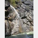
Reichenbachfall
Der Reichenbachfall ist eine 300 Meter hohe Kaskade von sieben Wasserfällen im Verlauf des Reichenbachs auf dem Gebiet der Gemeinde Schattenhalb südlich von Meiringen im Kanton Bern.[ click for more information ]
Camping Hofstatt-Derfli
A beautifully located campsite with a view of the mountainsopen 1 January - 31 December
[ click for more information ]
Badesee Hasliberg
Er befindet sich auf einer Höhe von 1191 Metern über Meer im Ortsteil Wasserwendi/Twing.[ click for more information ]
Naturfreundehaus Reutsperre
Inmitten des Reichenbachtales ist unser Naturfreundehaus Reutsperre ein Chalet gelegen auf einer Anhöhe auf 1310 m im Berner Oberland.[ click for more information ]
Falcherenbachfall
Der Wasserfall liegt am Fälcherenbach und hat eine Fallhöhe von 125m[ click for more information ]
Restaurant Urweid
The Urweid restaurant is located in Innertkirchen in the Bernese Oberland, Switzerland.[ click for more information ]
Engelhornhütte
The Engelhornhütte is located at the northeastern end of the Ochsental above the Reichenbachtal.[ click for more information ]