GIS24.net
Geographic Information System
POI database from MEINWOMOmaps


Geographic Information System
POI database from MEINWOMOmaps
Raiffeisen Grindelwald (Lütschinentäler)
Bank /
ADDRESS
 3818 Grindelwald
Dorfstrasse
Click for interactive map
..
Pictures of the Poi and surroundings
.
Things to see in the area
Coop
[ click for more information ]Indoor Seilpark Grindelwald
Europe´s largest indoor rope park in the Grindelwald sports centre.[ click for more information ]
Dorfstrasse
Self-Service Maschinen[ click for more information ]
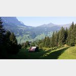
Camping Gletscherdorf
 A beautifully located campsite
is open 1 January - 31 December
[ click for more information ]
Allgemeiner Parkplatz
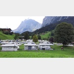
[ click for more information ]Campingplatz Eigernordwand
 The camp Eiger in Grindelwald is located directly on the ski slope and a cross-country track
is open January - December
[ click for more information ]
Eiger-Ostegghütte
The Eiger-Ostegghütte is a mountain hut at 2317m high at the foot of the Eiger-Nordostgrat.[ click for more information ]
Abbachfall
Waterfall in the municipality of Grindelwald at 1252m.[ click for more information ]
Berghaus Bäregg
Die Hütte befindet sich am Westhang des Mättenbergs auf einer Höhe von 1772 m in den Berner Alpen.[ click for more information ]
Mittellegihütte
The Mittellegi hut 3350m.[ click for more information ]
Bachalpsee
Der Bergsee im Gebiet Grindelwald First wird durch einen Damm zweigeteilt und liegt auf einer Höhe von 2265 Metern über Meer.[ click for more information ]
Hagelseeli
Das Hagelseeli liegt auf dem Gebiet der Gemeinde Brienz (BE) auf 2338 Metern über Meer.[ click for more information ]