GIS24.net
Geographic Information System
POI database from MEINWOMOmaps


Geographic Information System
POI database from MEINWOMOmaps
Emmerbølle
/
ADDRESS
 5953 Langeland Kommune
Emmerbøllevej
WeiterUrl : https:/ / de.wikipedia.org/ wiki/ Emmerbølle
UrlLoad : https:/ / yes
WikiText : Vorlage:Infobox Ort in Dänemark/Wartung/Fläche fehltVorlage:Infobox Ort in Dänemark/Wartung/Höhe fehltVorlage:Infobox Ort in Dänemark/Wartung/Bild fehlt Emmerblle ist ein kleiner Ort auf der dänischen Insel Langeland, westlich von Lejblle. Emmerblle ist Teil der Langeland Kommune in der Region Syddanmark. Vor der Kommunalreform zum 1. Januar 2007 gehörte Emmerblle zur Tranekr Kommune in Fyns Amt. Der Ort, der weniger als 200 Einwohner hat und daher von Dänemarks Amt für Statistik nicht ausgewiesen wird[1], wird durch einen nahe gelegenen Campingplatz touristisch geprägt.
Click for interactive map
..
Pictures of the Poi and surroundings
.
Things to see in the area
Emmerbølle Strand Camping
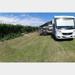 The course features generous spaces, it borders on a nature reserve
is usable 11 April - 19 October
[ click for more information ]
Anlegestelle Campingplatz
Boost jetty at Camping Emmerbølle Strand[ click for more information ]
Tranekaer Slot
In 1659 the Ahlefeldt-Laurvig family took over the Tranekaer Slot.[ click for more information ]
Tranekær Slot
[ click for more information ]Dageloekke Marina in Langeland
[ click for more information ]Dageløkke Havn
[ click for more information ]Tvedeskov Jættestue
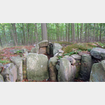 If you follow the signpost Jættestue into the forest on Bukkeskovvej on the island of Langeland, you will find yourself after 50 meters in front of a 5000-year-old grave from the Younger Stone Age.
 [ click for more information ]