GIS24.net
Geographic Information System
POI database from MEINWOMOmaps


Geographic Information System
POI database from MEINWOMOmaps
Seelisbergsee
/
ADDRESS
 6377 Seelisberg
Seelistrasse
WeiterUrl : https:/ / de.wikipedia.org/ wiki/ Seelisbergsee
UrlLoad : https:/ / yes
WikiText : Der Seelisbergsee, auf der Landeskarte der Schweiz kurz als Seeli bezeichnet, ist ein See unterhalb der Ortschaft Seelisberg im Kanton Uri, Schweiz. Der See ist etwa 18 ha gross, 700 bis 800 m lang, 350 m breit und eine Tiefe von 37 m, die wie eine Wanne beschaffen ist. Der Seelisbergsee befindet sich auf 738 m südwestlich des "Knies" des Vierwaldstättersees, also wo dieser in den Urnersee übergeht. Das Rütli, der Legende nach Geburtsort der Schweizer Eidgenossenschaft, liegt gleich in unmittelbarer Nähe. Der See liegt am steilen Nordhang des Niederbauen-Chulm (1923 m) in einer Senke. Der Zufluss erfolgt über unterirdische Einsickerungen, dann fliesst das Wasser in den kleinen See ab, von da an unterirdisch bis in den Vierwaldstättersee, wo es zwischen Rütli und Bauen unter der Wasseroberfläche wieder austritt. Der Untergrund im Bereich des Abflusses ist ziemlich zerklüftet und weist vermutlich ein weit verzweigtes Höhlensystem auf.
Click for interactive map
..
Pictures of the Poi and surroundings
Videos about the Poi and the surrounding area
.
.
Things to see in the area
Seelisbergsee
Der Seelisbergsee liegt in der Gemeinde Seelisberg im Kanton Uri auf 738 Metern.[ click for more information ]
Seelisberg
Seelisberg is a municipality in the canton of Uri in central Switzerland.[ click for more information ]
Parkplatz, auch zum Übernachten
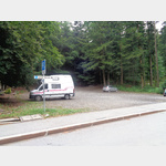 Small trail parking lot on the outskirts of Seelisberg
 is open 1 January - 31 December
[ click for more information ]
Rütli
The Rütli is a meadow and a historical place in Seelisberg, a municipality in the canton of Uri in central Switzerland.[ click for more information ]
Treib
Treib is a small town and a stop for steamboats on Lake Lucerne in Switzerland.[ click for more information ]
Der Schillerstein
The Schillerstein, also known as the Mythenstein, is an almost 30 meter high, prominent boulder that protrudes from the water at the entrance to Lake Uri, the southernmost basin of Lake Lucerne.[ click for more information ]
Restaurant Eichwald
[ click for more information ]
[ click for more information ]
Restaurant - Dancing Burgfluh
[ click for more information ]
[ click for more information ]
Restaurant reed
[ click for more information ]
[ click for more information ]
Church Roman Catholic
[ click for more information ]
[ click for more information ]
Hotel Waldstätterhof
[ click for more information ]
[ click for more information ]
bergbahn
Lift-bergbahn Urmiberg cable car[ click for more information ]
Tellskapelle
Tellskapelle The Tellskapelle is a chapel on the shore of Lake Lucerne three kilometers south of the village of Sisikon in the Swiss canton of Uri.[ click for more information ]
Hotel City Hotel
[ click for more information ]
[ click for more information ]
Hotel Brunnerhof
[ click for more information ]
[ click for more information ]
Wandern
Hiking trail Short hiking trail to Tellskapelle[ click for more information ]
Restaurant Mezcalito
[ click for more information ]
[ click for more information ]