GIS24.net
Geographic Information System
POI database from MEINWOMOmaps


Geographic Information System
POI database from MEINWOMOmaps
Nationalpark Ordesa y Monte Perdido
/
ADDRESS
BielsaWeiterUrl : https:/ / de.wikipedia.org/ wiki/ Nationalpark Ordesa y Monte Perdido
UrlLoad : https:/ / yes
WikiText : i3i6 Der Nationalpark Ordesa y Monte Perdido, kurz auch Ordesa-Nationalpark, ist ein Nationalpark in den spanischen Pyrenäen in der Provinz Huesca. Er wurde am 16. August 1918 zum Nationalpark erklärt und ist damit der älteste in den Pyrenäen. Teil des Nationalparks ist der 3.355 m hohe Monte Perdido, der seit 1997 zum UNESCO-Welterbe gehört. Der Nationalpark in seiner jetzigen Größe besteht seit einer Erweiterung 13. Juli 1982 und erstreckt sich auf einer Fläche von 15.608 Hektar und verteilt sich auf die Gemeinden Torla (2.315 ha), Fanlo (8.265 ha), Tella-Sin (731 ha), Purtolas (2.473 ha) und Bielsa (1.824 ha). Rund 600.000 Menschen besuchen den Nationalpark pro Jahr.
Click for interactive map
..
Pictures of the Poi and surroundings
.
Things to see in the area
Auf den Monte Perdido vom Refugio de Goriz
[ click for more information ]Lago de Pinets de Maebore
[ click for more information ]Monte Perdido
[ click for more information ]Parkenwomo
[ click for more information ]Puerto de Lera
[ click for more information ][ click for more information ]
Parkplatz Valle de Pineta
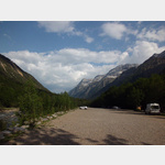 Hiking car park at the Valle de Pineta, an ideal starting point for hikes in the Ordesa Nature Park, including to the waterfalls of the Rio Cincain, which is pretty full during the day during the season, at night there is only the sound of the river.
 [ click for more information ]
[ click for more information ]