GIS24.net
Système d´information géographique
Base de données POI de MEINWOMOmaps


Système d´information géographique
Base de données POI de MEINWOMOmaps
Ammersattel
/
ADRESSE
Ettaler ForstSt 2060
WeiterUrl : https:/ / de.wikipedia.org/ wiki/ Ammersattel
UrlLoad : https:/ / yes
WikiText : Vorlage:Infobox Pass/Wartung/Bild fehltVorlage:Infobox Pass/Wartung/Profil fehlt Der Ammersattel ist ein 1.118 ,m hoher Gebirgspass in den Ammergauer Alpen. Der Sattel befindet sich in unmittelbarer Nähe der Grenze zwischen Deutschland und sterreich, die Passhöhe selbst liegt jedoch zur Gänze auf Tiroler Gebiet. Die über den Ammersattel führende Straße (in Deutschland: Bayerische Staatsstraße 2060, in sterreich: Tiroler Landesstraße 255) verbindet Ettal bei Oberammergau (im Landkreis Garmisch-Partenkirchen) und Reutte in Tirol (im Bezirk Reutte). Die Passhöhe liegt zwischen der Hochplatte (2.082 ,m) im Nordwesten und dem Scheinbergspitz (1.926 ,m) im Norden sowie dem Kreuzspitz (2.185 ,m) im Südosten und den Geierköpfen (bis 2.161 ,m) im Südwesten, wovon die drei zuerst genannten Berge in Deutschland aufragen.
Cliquez pour une carte interactive
..
Photos du Poi et des environs
.
Choses à voir dans la région
Bergpass
Ammersattel Allemagne-Autriche| L255/ST2060 Reutte-Oberammergau 1082m 14% 30km[ cliquez pour plus d´informations ]
Parkplatz, auch zum Übernachten
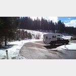 Wanderparkplatz, à 20 mètres de la frontière germano-autrichienne, point de départ idéal pour des randonnées
est utilisable 1 Janvier - 31 Dêcembre
[ cliquez pour plus d´informations ]
Scheinberg-Spitz
112848_Beschreibung[ cliquez pour plus d´informations ]
Geierköpfe
Pic principal, 2161 m[ cliquez pour plus d´informations ]
Weitalp-Spitz
112426_Beschreibung[ cliquez pour plus d´informations ]
Vorderer Schein-Berg
Front Sparkle Mountain 1827m[ cliquez pour plus d´informations ]
Brandjoch
112565_Beschreibung[ cliquez pour plus d´informations ]
Schellschlicht
Arrivée rapide 2053m[ cliquez pour plus d´informations ]
Kuchelberg-Kopf
Tête Kuchelberg 2026m[ cliquez pour plus d´informations ]
Große Klammspitz
Grand Klammspitz 1924m[ cliquez pour plus d´informations ]
Kenzen-Kopf
Tête de Kenzen 1745m[ cliquez pour plus d´informations ]
Kleine Klammspitz
Petite Klammspitz 1882m[ cliquez pour plus d´informations ]
Hochplatte
113679_Beschreibung[ cliquez pour plus d´informations ]
First-Berg
Première montagne 1784m[ cliquez pour plus d´informations ]
WohnmobilTAGESparkplatz Sägertal
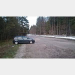 Größerer Parkplatz am Eingang des Sägertals, KEIN Übernachten, Kein campingartiges Verhalten (Sollte durch Signet und roten Text eigentlich klar sein.
 [ cliquez pour plus d´informations ]
Roßstallkopf
Rossstallkopf 1483m[ cliquez pour plus d´informations ]
Brunnen-Kopf
Tête de fontaine 1719m[ cliquez pour plus d´informations ]