GIS24.net
Geographic Information System
POI database from MEINWOMOmaps


Geographic Information System
POI database from MEINWOMOmaps
Rauhekopfhütte
/
ADDRESS
 6524 Kaunertal
WeiterUrl : https:/ / de.wikipedia.org/ wiki/ Rauhekopfhütte
UrlLoad : https:/ / yes
WikiText : Die Rauhekopfhütte ist eine Alpenvereinshütte der Sektion Frankfurt am Main des Deutschen Alpenvereins. Sie liegt im hinteren Kaunertal im Weißkamm in den tztaler Alpen. Die Rauhekopfhütte wurde 1888 erbaut und 1939 und 1977/1978 erweitert.
Click for interactive map
..
Pictures of the Poi and surroundings
.
Things to see in the area
Fluchtkogel 3500 m
[ click for more information ]Gepatschjoch 3241 m
[ click for more information ]Italien
[ click for more information ]Parkenwander
[ click for more information ]Grosser Nöderberg 2885 m
[ click for more information ]Kleiner Nörderberg
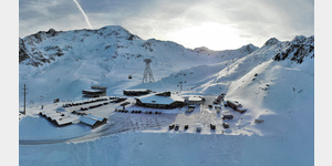
[ click for more information ]Wohnmobilparkplatz Talstation Ochsalmbahn
 In summer and winter, mobile homes are parked in the car park at the valley station of the Ochsalmbahn.
 [ click for more information ]
Italien
[ click for more information ]ParkenAll
[ click for more information ]Kaunertaler Gletscher
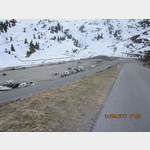
 At the highest point of the Kaunertal Glacier Road there are mobile homes both in summer and especially in winter.
 [ click for more information ]